Belmont Mound, just a few miles outside of Belmont Wisconsin near the First Capitol Historic Site, rises from its base of 1,000 feet above sea level 400 feet into the air and is covered with trails used by hikers, horseback riders, and cross-country skiers alike. It’s name comes from French, belle monte or “beautiful mountain,” though most would hardly consider an elevation 1400 feet above sea level to be mountainous!
Hidden away on the eastern side near the picnic area, you can also find some abandoned lime kilns, nearly covered by the profusion of stately oak and walnut trees. More on that kiln later in this article.

Belmont Mound is one of many large “mounds” in the area that are actually worn down mountaintops capped with dolomite, like the nearby Platte, Sinsinawa, Blue, and Horseshoe Mounds (and not to be confused with the conical, linear, and effigy mounds created by the ancestors of the Ho-Chunk, Potowatomi, and other native peoples of this area.)

To get there, take either take County Road G from Platteville or take the Belmont exit from Highway 151. Then, um… look for the large mound! The Belmont Lion’s Club maintains the park and you’ll find parking and shelters at the entrance. The road after that is now blocked to cars, but you use this easy paved road as a pedestrian path to where the observation tower used to stand.
These larger mounds have served as navigation markers for humans for hundreds if not thousands of years: in fact, the reason the 1836 Wisconsin Territorial capitol was located where it was, near Belmont, is likely because it was easy to find and locate the spot in what was then the state’s most populous area, the southwest Wisconsin lead mining region. (The Territorial Legislature only met at that capitol once, in 1836, then after two sessions in Burlington, Iowa they moved to Madison, Wisconsin.)
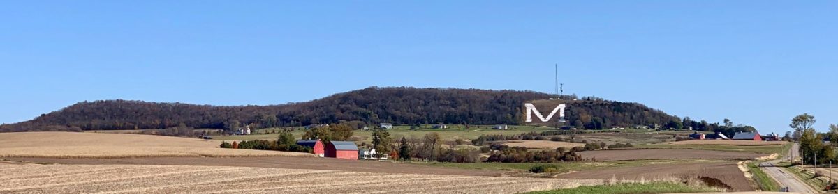
As we’ve talked about in earlier articles on the nearby Platte or Platteville “M” Mound, the geology of these mounds is what makes them so great to hike upon. On the north side of the mound, you’ll find structures like “Devil’s Dining Table” and “Devil’s Chair” . . . and you can have some fun making up names of your own, since the trails are marked, but without names.
“But wait,” I imagine someone saying, “didn’t you say something about a great observation tower there?”

Yes, there is one, but not for long, and please don’t use it. The 64-foot observation tower at the Mound’s top is scheduled to be dismantled soon. Once, from the top of the tower at night, you could see the lights of Dubuque, Iowa and Galena, Illinois. During the day you could see Lancaster, Wisconsin, 20 miles away. Most prominently, you could also see the back of the Platte Mound in nearby Platteville (to the west) and the largest of the two Blue Mounds, in Blue Mound State Park, to the northeast.

Unfortunately, three people have committed suicide at different times by jumping from the Tower. Along with those tragedies, according to Lion’s Club members, were other problems, such as people pitching everything from televisions to rotten pumpkins off of the top of the Tower and leaving it to the Lion’s Club to clean up. Because of that, even before the most recent suicide, the Lion’s Club had decided they could no longer maintain the Tower, and it is closed.
(Well, that was a major downer. Let’s shift to some of the hikes and other things you can find at the Mound!)

As mentioned, there are a host of hiking trails around Belmont Mound. Like the other large mounds in the Driftless area, Belmont Mound sits on a deep granite base and was likely a mountain millions of years ago. About 500 million years ago (during the Cambrian geologic period), a very thick layer of mainly sandstone with some limestone mixed in blanketed the granite, followed a few million years later (during the Ordovician Period) with additional blankets of shale, limestone and sandstone. All that was then covered by a particular kind of limestone, Niagara dolomite, in the Silurian period. Since no glacier covered this area during the last ice age, the mountain was never totally eroded… and since limestone in particular holds its form even while very, very slowly dissolving in places where there’s water, its particular chemical structure lends itself to the creation of lots of caves, gorges, and rock outcroppings.


The most-noticed cave is located just a few yards north of the Devil’s Dining Table. Take a flashlight and a friend if you want to go through it… its an unlit passage of about 25 feet through a huge rock, and hard to miss. No, that picture on the left is not it. That’s just to tempt you.
The best time for hiking or horseback riding is early spring or late fall, as some trails tend to get overgrown in summer and if you’re horseback riding, your horse won’t appreciate all the thorny berry bushes. On the other hand, if what you’d prefer to do is pick gooseberries or black raspberries, you’ll find them all over the place in late summer, and morel mushrooms a month or so before that. Don’t hike during hunting season, as the area is also a favorite destination of local hunters.

If you aren’t up for caving, berry-picking, or hunting, and you don’t want to hike too far, you might want to explore the history of the area a bit. There’s a mysterious old lime kiln that is within 100 yards of the picnic area. In fact, the picnic area itself is the site of an old lime quarry.
While I have not been able to find the name of whose lime kiln it was, I’m certain that’s what it is, and the type of construction makes it appear that it was made by early settlers from the British isles. (If I find out who operated the kilns, I’ll post that here. However, British isles settlers–Cornish miners but not only them–came with knowledge of how to make kilns to extract lime for use in agriculture and manufacturing processes, because they’d made similar ones in their native country. A similarly constructed lime kiln can be found over in Grant county near British Hollow, on Hippy Hollow Road.)


Getting to the kilns is simple: if you’re at the main picnic area facing away from the road, you should see another small shelter to the right. The trail is right behind that. You may not see the kilns until you’re almost upon them, but if you’ve gone more than a quarter-mile you’ve gone too far.
Belmont Mound is also a great spot for bird-watching, thanks to the huge old oaks that populate its sides. I’ve seen Cooper’s hawks and bald eagles there both, especially in November and December.
The park’s trails are not maintained in winter, but are nonetheless sometimes used by snowshoers. There is a 2.5 mile cross country ski trail nearby. The trail pictured below, which you’ll intersect on the way to the lime kilns, is just over a mile long and usually called “Mound Loop Trail.”

One last thing… if you’re driving to the Belmont Mound from Platteville on County B, you’ll probably drive by the “Little” or “Mootz” mound. It’s on private property, but mentioned here since its yet another of the large mounds in the area: a list across three states that includes the Platte, Belmont, Blue, Horseshoe, Charles, Sherill and Sinsinawa Mounds.

Unless noted, all photos by Terry Burns
Tell us about your favorite place in the Driftless Region!