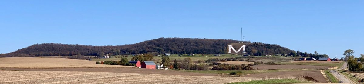
Make no mistake about it: people in tiny Platteville, Wisconsin love this Mound. It is definitely the most famous (though not the highest) of the mounds in group of mound complexes you can find in the southwest part of the Driftless Region, simply because the big “M” makes it hard to miss. In fact, the Platte Mound is featured on Platteville postcards you can buy at the Chamber of Commerce (see below). Kip Schreck took this with his Powered Parachute… now tell me that isn’t cool!


But you don’t have to parachute in to get to the top of the “Big M.” Just drive to the base and walk up. Actually, it’s a great way to get in shape, and in summer, you may see the more athletic of visitors running up and down the wooden stairs: almost 300 of them, 266 of which bear the names of the sponsors that helped fund its building. From the top, there’s a spectacular view of the surrounding area.


So… let’s say you’ve pulled into that parking lot at the base of the “M,” and maybe you wonder why it’s there. Well, yeah, you could read the sign, but it won’t help you much… it says “the World’s Largest M” is the symbol for UW-Platteville’s College of Engineering (which would mean it should be an E, maybe?)

But if you have someone with you who’s from around here, maybe they’ll jump in and tell you that the “M” is for “Mining,” because the part of what’s now the University of Wisconsin-Platteville that was an old mining school got into a battle with the Colorado School of Mines to see who could make the biggest “M”… back in the 1930s. But the mining engineers did build it, and current engineering students keep it whitewashed, just like it’s some alphabetic version of Tom Sawyer’s picket fence. In fact, the “M” was until recently part of UW-Platteville’s logo. But all of that is another story, one that winds back through the mining history of Platteville’s recent past. It’s a good story, though not one we’re going to hear today.
Maybe like me, you also wonder what people thought about the Mound before the miners arrived. Surely it was some sort of sacred sight. Did people live on it it? Or maybe you’ve heard stories of UFOs doing fly-bys on the mound… or maybe you just think all this storytelling is just sort of Mickey Mouse.
Guess what? You’re right (at least about the last thing)! On July 4, 1998, the big “M” lit up with Mickey between its peaks (see below). Maybe your guide was part of the Disney Hometown Parade that came to Platteville that year… or maybe they helped whitewash the Mound (especially if your guide is an engineering graduate of UW-Platteville) or danced or played with the band at the annual Miner’s Ball held at its base. Dancing in the twilight of a torch-lit giant letter may be strange, but its a lot of fun.

But for me– not being an engineer, band member, stair runner, or even a good rock whitewasher– the real fun comes from hiking around on top of the Platte Mound and taking pictures. Since every season *but* winter is a good time for hiking, I thought I’d talk about that first, and save the history for another post this winter. So if you want to know more about the Mound’s history… I’ll get to it, but not today.
Seasons on the Mound
If you just want to see the view, summer is definitely the best time. Want to watch a beautiful sunset? The easiest direction to look from the top is west.

Also, if you just want to exercise by running up and down the steps, any time where the temperature’s above freezing will do. (Trust me, you don’t want to run up those stairs when there’s any chance of ice.)
Or… if you’ve read our earlier article on the mound complexes and know how the tallest Blue Mound and Platte Mound and Sherrill Mound all line up, then maybe you want to know how to see Sherrill Mound. (After all, it doesn’t have a big letter on it to make identification easy.) Just look for the two irrigation ponds you see in the photo below, then look up to the horizon. There it is!


But if you really want to explore, then take a hike on the top. The best time for that is early fall or late spring, not summer. For one thing, the foliage that grows thick during the summer months includes plenty of stickers and berry bushes–gooseberry and black raspberry, mainly–with thorns. Also, if you like the view, you won’t be able to see much through all the greenery in summer.
Once you climb the stairs to the top, you’ll be facing some ugly cell phone towers (all of the local mounds have cell phone towers on their tops, for obvious reasons–they are the highest spots in the area– though these towers really are eyesores and sometimes give off an annoying hum.)
At the top, you’ll see unlabeled yet pretty obvious paths heading right (south) or left (north). For the shortest and safest hikes, turn right. For more adventure and wilder scenery, turn left.
The Right (South) Path

The path that heads south will give you a great view of nearby farm country, including several Amish farms which regularly advertise fresh produce through late summer and fall, and fresh eggs year-round. After you wind along the ridge for a very short while, you’ll run into various forks. Don’t worry… you can’t really get lost on this side. If you decide to go off-trail, all you need to do to find that trail again is uphill. If you stay on the gravelly top, you may actually wind up walking on to the cell phone tower service road (which used to be open, but is now locked to keep non-service-people from driving up.)

If you veer off to the right or south side (that is, if you have turned right then turn right again), and if you’re a lot taller and more athletic than I am, you’ll find several places where you can scramble up rocks that have quite an overlook, like this one to the left.
You can also get an idea of how the mounds were formed. Platteville limestone, formed by crushed invertebrates from some ancient sea, is named for this part of Wisconsin. You’ll see layers of this hard-to-erode stone that have been pushed up by even stronger geologic forces.


Anyway, the south ridge is the easiest to explore if you don’t have a lot of time. If you wind too far down the slope, you could actually be taking an alternate route to the bottom, but I wouldn’t. Yes, those are private residences at the bottom. But there are reasons beyond general respect for privacy that you might want to head back up rather than down.
Time for a little teaser: there’s one backyard in particular you want to be careful of not because of the owners (who are quite nice) but because the house itself is structurally unsound.
You may have heard of it, sometimes called the Platte Mound’s “Haunted House,” or written up in various accounts as the site of the “Nodolf Incident.” That’s yet another story for a different day. For now, our advice is to just stay away! Do not go inside. It isn’t safe. But it’s a fun story for some later cold, winter day… one where the mound liikes like this:

We’ll leave hikers with this thought: what if, at the top of the mound, we went left or to the north instead? That’s another whole story! Be back next week with
Caves, Crevices and Campfires: the North End of the Platteville “M” Mound.
[Editor’s note: since the Platte Mound is so heavily associated with Platteville, the most populous city in Grant County, though it’s actually across the county line in Lafayette County, we’ve tagged it for both places.]
Check out this topo map of the Platte Mound!
Unless noted, all photos by Terry Burns
Tell us about your favorite place in the Driftless Region!