by Terry Burns, Kristal Prohaska, and Laurie Graney
May 31, 2022
As some readers know, we have used this site to communicate our research into the history of Indian Park in Platteville, Wisconsin. Back in 2020, we posted three articles on this blog-site, then updated them in January 2022 with information obtained during research partially supported by a Wisconsin Humanities Mini-grant:
Since that time, we have uncovered more information and answered a few more questions.
Because of that, we’ve recently updated those articles. Because the articles did not contain any incorrect information, we decided to simply add the new information to those old articles. Where we have added new information, you will find that reflected in the articles.
The three of us have also given several presentations now on the history of “Indian Park” in Platteville. Here are the slides and handouts for that presentation:
We’re looking for winter stories! Do you ski, snowshoe, or snowmobile? Make artsy snowmen? Know of good ice carvings or good spots to go ice fishing? Write about it and submit an article to us!
Hello, everyone! As the temperatures drop, it’s a good time to turn inward. Our next several posts will concern the history of the area. We’re delighted to introduce local writer and filmmaker Nettie Potter, who will be sharing several articles on topics she’s presented on locally… the murder in Coffee Woods, the spirits of Walker House, the the “Nodolf Incident” at the Platte Mound. We’ll be running one of Potter’s stories each week for the rest of January and all of February (along with whatever other articles may pop up on here!)
Just in case you’d like a teaser, here’s a video of what Nettie will be talking about in her article on “The Spirits of Walker House.”
That William Caffee, by the way, has no connection (beyond the phonological one, and that Nettie Potter is writing on them) to the William Coffee of the Coffee murder.
Do you have a story involving local history? Write about it and submit an article to us! We’d love to read your work.
Like our earlier piece on fall color, this post will be long on photos and short on text!
One of our favorite things to do on a cold winter day is to visit some of our favorite spots along the Mississippi. As the ice slowly freezes, the bald eagles that range along the river bluffs finally move south. The ice isn’t quite thick enough for fishing huts like the ones which will pop up on nearby lakes soon. But the cold, clear air and the striking blues of sky, ice and river make places that are usually filled with people look pristine.
The Mississippi River as view from Grant River Recreation areaMississippi River viewed from Potosi Point
A beaver dam as seen from Potosi Point
Of course, it’s really not as pristine as all that… you can find plenty of beaver dams, occasional deer running into the woods, and a few remaining waterfowl. But what I love the most is the deep blues of the water as it freezes.
These photos were all taken between (or in) the Grant River Recreation Area and Potosi Point.
A few remaining geese coming in for landing….
… and they’ve landed!
The road out onto Potosi PointWho says you can’t take pictures into the sun?
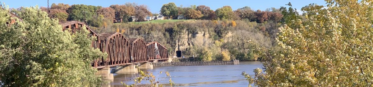
The Soo Line Railway (a subsidiary line of the Canadian Pacific) running along the Wisconsin shore. It crosses over from La Crescent, Minnesota up at La Crosse.
Looking north from Potosi PointOne last look south from the Point before I head home.
with a side trip to Hyde Blacksmith Shop and the old stage stop
A favorite stop for local photographers is Hyde’s Mill, in Iowa County Wisconsin near Ridgeway. It must be the most photographed old mill in the state! But the drive through Hyde Valley will also take you by many other picturesque sites, including an old blacksmith shop, stage stop, and the one-time Hyde store, now a local watering hole for hunters, football fans, and wandering photographers.
Hyde’s Mill near Ridgeway is a favorite place for fall color pictures
We’ll start and finish with what most take as the highlight: the rare old wooden water wheel mill. First built by settler William Hyde in 1850, it burned down in 1870 and was rebuilt by “Ted” Sawle at its original site next to the 1850s stone dam. To get there, you’ll want to drive about five miles north of Ridgeway (or seven miles south of Arena) on County Highway H, or just google “Hyde’s Mill.” You’ll turn off Highway H on (not surprisingly) Mill Road.
Hyde’s Mill in August. Catching this site at different times of year is a favorite hobby for photographers!Hyde’s Mill in winter. I was experimenting with long-exposure photography that day!
The restored old mill house, built in 1870
The Sawle family owned the mill from 1931 until around 2012. According to a Wisconsin State Journalarticle, the site includes “the wooden mill house, its idle wheel, eight acres of land and a hydroelectric plant that generates up to $300 worth of electricity a month.” The current owners prefer to not be identified.
It appears that the Sawle family, making a virtue of necessity, developed quite a collection of old mill stones! They’re lined up to the left of Mill Creek on old Mill Road. We’ll leave it to you to interpret the Biblical verse that introduces them.
The main millstone headed by this quote from Deuteronomy: “No man shall take the nether or the upper millstone to pledge: for he taketh a man’s life to pledge”
The Sawle family wound up with quite a collection of mill stones over the years!
While you’re in the area, you might want to take a five-minute drive south on Highway H through Hyde Valley, which is itself a beautiful drive. You’ll go past a little tavern, which for generations served as the Hyde Valley general store. Rumor has it that it’s a great place to watch Packer games!
If you keep going south, you’ll get to the Hyde Blacksmith shop. This yellow-stone building contains quite a story. According to Jeanie Lewis in her 2012 DodgevilleChronicle article, the shop was originally located down the road at the Dick Keene farm, but taken apart brick by brick in 2000. For a few years, the stones were stored inside while the Hyde Blacksmith Shop Territory committee raised funds.
In 2008, a local stone mason, Art Kirsch, offered to rebuild the shop for a fraction of the estimated cost, something the Territory group considered a “godsend.” Rebuild it he did, at its current location on the Ruggle’s farm on County Highway H.
The restored Hyde Blacksmith shop, located on the Ruggle’s Farm in Hyde Valley about a mile south of Hyde Mill.
Hyde Blacksmith Shop usually hosts an open house and family days in June or July, though it was cancelled this year due to COVID-19. For next year’s information, you might want to check their Facebook page.
This sign near the restored Hyde’s Blacksmith Shop gives these dates: Ruggle’s Farm (1840); Stagecoach Stop (1844-1883); House (1843); Barn (1852)
The old stagecoach stop, along what is now County Highway Trunk H
The current Highway H runs along the old stage route, and the Ruggles’ farm includes one of the old stage stops. Before the trains came and went as a source of local transportation, the stagecoach was how early settlers made it from place to place. At that time, Hyde Valley was a thriving intersection and the main stage stop between what was then a much-larger Arena, Wisconsin and Wisconsin’s third oldest city, Mineral Point.
We’ll start this piece where we began, at the old Hyde Mill. Long-time owner Theodore “Ted” Sawle maintained it as a working mill for decades and became somewhat of a legend in the area. Along with making this water wheel, he crafted two others, one of which was the 18-foot-wheel still on display in Indiana, which he made for Daniel Boone’s brother, Squire Boone.
Ted Sawle also fought and won a heated 1970s battled with the DNR over water rights. The state does not want any mills or dams on navigable waterways… but the Hyde Mill and Dam had been in the valley years before the state made that decision. Sawle contested it and ultimately won. When he passed on in 2009, he was over 104 years old.
If you visit, please respect the many “no trespassing” signs in front. All of the photos taken here were taken from behind the fence, and its not hard to imagine that the old structure can’t really tolerate lots of people climbing around on it. Though Ted Sawle is gone, his warnings and desire to protect this beautiful old site still remain!
The stone dam was built two years after Wisconsin attained statehood
Ted Sawle’s old sign asking visitors to stay behind the fence!
Unless noted, all photos by Terry Burns
Tell us about your favorite place in the Driftless Region! We’re accepting submissions.
Dickeyville, Wisconsin’s Grotto on the summer solstice.
The Midwest is blessed with a fascinating legacy of religious structures created primarily by German immigrants. . . . the real architectural gems stemming from the immigrants may be the incredible religious grottoes of the Midwest, which are considered among the most important folk or “outsider” art environments in the United States.”
Yes, it feels strange to use the word “grotto” for structures basically built of stone mixed with concrete then embedded with sparkling glass, shells, and whatever else the builder could find, but let’s just go with it for a moment… and go to one of these grottoes. They are some of the most fascinating specimens of folk art in the area. A grotto (or cave) in this sense means the inside of a shrine, and they became popular about 100 years ago in the Midwest.
My favorite Driftless Region grotto is just off of US 151 in Dickeyville, Wisconsin, about ten miles from the bridge across the Mississippi River into Iowa. It sits on the grounds of the Holy Ghost Parish, right on the main drag in Dickeyville. Entrance to the Shrine of the Blessed Virgin is free, though donations are appreciated. As the Grotto approaches 100 years of age, it requires more than a little bit of upkeep.
Inside the Shrine of the Blessed Virgin at the Dickeyville Grotto
Typically most grottoes are built around a main shrine, usually to the Virgin Mary, and this one is no different. Inside the building you see at the top, you’ll find the 25 feet tall, 30 feet wide and 25 feet deep shrine… yes, it’s large, but it isn’t the size that draws most people’s attention. It is all the shiny items placed around the object of adoration.
Out from the base of the shrine, one may see several huge crystals, the largest of which is more than two feet tall!
Along with Mother Mary holding baby Jesus, you’ll find a collection of objects ranging from stalagmites that seem to be growing up from the floor at her feet, and coral, shells, rocks from around the country, and many other items. This is the handiwork of Father Matthias Wernerus, who was Pastor of the Parish from 1918 to 1931, and built the different shines from 1925-1930. Mother Mary’s shrine was finished in 1929.
Yes, that’s real petrified wood making up the Tree of Life on the back of the shrine.
Father Matthias apparently began collecting things, asked his congregation members to collect things, and before long, he even had Ford Motor Company in Detroit sending him building materials! (Henry Ford sent him those round balls that used to be on top of the Model T stick shifts. They appear most prominently in the Sacred Heart shrine behind the main church.) The church website notes that six or seven truckloads of thirty tons each came from the Dakotas, from Iowa, and from nearby Wisconsin quarries.
Behind the main shrine, you’ll find the stations of the cross, similarly decorated with shiny items ranging from rose quartz to colored glass
The brochures available at the entrance states that it is “a creation in stone, mortar, and bright colored objects” from all over the world, including “colored glass, gems, antique heirlooms of pottery or porcelain, stalagmites and stalactites, sea shells of all kinds, starfish, petrified sea urchins and fossils, and a variety of corals plus amber glass, agate, quartz, ores such as iron, copper and lead, fool’s gold, rock crystals, onyx, amethyst and coal.” Some items, like the large amount of petrified wood, stalagmites, stalagtites and the huge crystal quartz points set out in front of the Blessed Virgin’s feet, would not be obtainable today
If you are Catholic, you might want to learn more about the church and its parish or visit their gift shop. In this piece, I’m addressing the Grotto as an inspired work of folk art, but I do not presume to be an expert on Catholic shrines.
The author having some fun with one of the reflecting balls at the Grotto.
Try to go on a sunny day, and you can get some truly amazing pictures. Maybe Dickeyville can consider the Grotto’s little reflecting balls their version of Chicago’s Bean. Because of the orientation of the building, its much easier to catch the sun reflecting off the back of the main shrine than off the front. In fact, to get the front of the Grotto in the sun, you really have to be there just before high noon and ideally in the late spring or summer! I’ve been told that shrines are supposed to be constructed so that the sun never shines directly inside of them… which means it rarely shines on the front door, either. The very top picture, taken just before noon near the summer solstice, is the closest I’ve ever come to getting the front illuminated by the sun. On the other hand, it is easy to get beautiful sun-lit photos of the Tree of Life which adorns the back side of the main shrine.
The Sacred Heart Shrine, whose banded pillars include old shifter balls from Model T Fords
The grotto has several other works of art. To the left, you’ll see the Sacred Heart shrine, which reproduces an altar erected in Chicago at Soldiers’ Field during the 1926 International Eucharistic Congress. The rock for the four pillars came from New Mexico, and they’re banded in a combination of colored glass and shifter balls from old Model T Fords! (Don’t ask me why the sun can shine on this Corpus Christi altar and not on the Blessed Virgin… as I’ve said, I am no expert on this type of sacred art.)
As you can imagine, one of the most popular secular activities at this sacred site is trying to identify the different components used in the building! The garden and birdhouses in front of the gift shop are similarly decorated with bright, shiny, and often antique objects.
Construction started
Construction ended
Shells, stones…
Dyed crystal points
Faith, Hope, Charity…
the greatest of these is Love
As folk art, most of Dickyville’s Grotto is delightful. There are several other shrines, though I’ve pictured the main ones here. A final shrine, not to God but to patriotism, I personally avoid… not because I’m not patriotic, but because it seems devoted to an outdated sort of “patriotism” celebrating, among others, Christopher Columbus. I understand that this was the view of European Catholic immigrants 100 years ago and part of what Father Matthias celebrated, but since I do not, I’ve chosen to not represent that part of the Grotto in this article.
Instead, I’ll end with some other photos of things I’m happy to celebrate–among them, Wisconsin deer!–then end with a photo of the Grotto in winter.
The garden behind the main shrine The Grotto in winter
Tell us about your favorite place in the Driftless Region!
That’s the “Little Mound” on the right with the transmission antenna coming out of it; Belmont Mount is visible to the left.
Today’s article won’t be long. But for those of you who are interested in the large mounds in the area– a list across three states that includes the Platte, Belmont, Blue, Horseshoe, Charles, Sherill and Sinsinawa Mounds–you sometimes see reference to a, or the, “Little Mound.”
For instance, at the top of one of the Blue Mounds, you even can see a diagram that shows you where “Little Mound” is, about 24.5 miles southwest of the Blue Mound right between the Belmont and Platte Mounds. If you’ve been to either of the latter two places, you may have driven right by it (and if you did, did you try to read that word on the western side? What does it say?)
Helpful though slightly vandalized signage at the top of Blue Mound’s west observation tower points out some of the mounds visible from this point, the highest in the Driftless Region.
Those words on the Little Mound spell “Mootz”
“Little Mound” sits about a half-mile west of the Belmont Mound (and about a half-mile east of the Platte or “M” Mound) on County Highway B. It’s on private property, and was once part of a large farm belonging to Don Mootz… and that, plus the large “M” for “Mining” on the Platte Mound, is probably why it too sports a large “M”… in this case followed by the rest of the “Mootz” name! It was very visible even ten years ago, but has become illegible in recent days.
Below, have a look at the Little Mound in winter… and that’s it for today’s road trip!
The Little Mound in winter
Unless noted, all photos by Terry Burns
Tell us about your favorite place in the Driftless Region!
Belmont Mound, just a few miles outside of Belmont Wisconsin near the First Capitol Historic Site, rises from its base of 1,000 feet above sea level 400 feet into the air and is covered with trails used by hikers, horseback riders, and cross-country skiers alike. It’s name comes from French, belle monte or “beautiful mountain,” though most would hardly consider an elevation 1400 feet above sea level to be mountainous!
Hidden away on the eastern side near the picnic area, you can also find some abandoned lime kilns, nearly covered by the profusion of stately oak and walnut trees. More on that kiln later in this article.
Belmont Mound is one of many large “mounds” in the area that are actually worn down mountaintops capped with dolomite, like the nearby Platte, Sinsinawa, Blue, and Horseshoe Mounds (and not to be confused with the conical, linear, and effigy mounds created by the ancestors of the Ho-Chunk, Potowatomi, and other native peoples of this area.)
To get there, take either take County Road G from Platteville or take the Belmont exit from Highway 151. Then, um… look for the large mound! The Belmont Lion’s Club maintains the park and you’ll find parking and shelters at the entrance. The road after that is now blocked to cars, but you use this easy paved road as a pedestrian path to where the observation tower used to stand.
These larger mounds have served as navigation markers for humans for hundreds if not thousands of years: in fact, the reason the 1836 Wisconsin Territorial capitol was located where it was, near Belmont, is likely because it was easy to find and locate the spot in what was then the state’s most populous area, the southwest Wisconsin lead mining region. (The Territorial Legislature only met at that capitol once, in 1836, then after two sessions in Burlington, Iowa they moved to Madison, Wisconsin.)
As we’ve talked about in earlier articles on the nearby Platte or Platteville “M” Mound, the geology of these mounds is what makes them so great to hike upon. On the north side of the mound, you’ll find structures like “Devil’s Dining Table” and “Devil’s Chair” . . . and you can have some fun making up names of your own, since the trails are marked, but without names.
“But wait,” I imagine someone saying, “didn’t you say something about a great observation tower there?”
The observation tower still stands, but the Lion’s Club plans to dismantle it for liability reasons.
Yes, there is one, but not for long, and please don’t use it. The 64-foot observation tower at the Mound’s top is scheduled to be dismantled soon. Once, from the top of the tower at night, you could see the lights of Dubuque, Iowa and Galena, Illinois. During the day you could see Lancaster, Wisconsin, 20 miles away. Most prominently, you could also see the back of the Platte Mound in nearby Platteville (to the west) and the largest of the two Blue Mounds, in Blue Mound State Park, to the northeast.
You can walk up the old car road the the now-closed observation tower.
Unfortunately, three people have committed suicide at different times by jumping from the Tower. Along with those tragedies, according to Lion’s Club members, were other problems, such as people pitching everything from televisions to rotten pumpkins off of the top of the Tower and leaving it to the Lion’s Club to clean up. Because of that, even before the most recent suicide, the Lion’s Club had decided they could no longer maintain the Tower, and it is closed.
(Well, that was a major downer. Let’s shift to some of the hikes and other things you can find at the Mound!)
The author took this picture of the back of the Platte or Platteville or “M” Mound a few years back, before the observation tower was closed.
As mentioned, there are a host of hiking trails around Belmont Mound. Like the other large mounds in the Driftless area, Belmont Mound sits on a deep granite base and was likely a mountain millions of years ago. About 500 million years ago (during the Cambrian geologic period), a very thick layer of mainly sandstone with some limestone mixed in blanketed the granite, followed a few million years later (during the Ordovician Period) with additional blankets of shale, limestone and sandstone. All that was then covered by a particular kind of limestone, Niagara dolomite, in the Silurian period. Since no glacier covered this area during the last ice age, the mountain was never totally eroded… and since limestone in particular holds its form even while very, very slowly dissolving in places where there’s water, its particular chemical structure lends itself to the creation of lots of caves, gorges, and rock outcroppings.
The geology of Belmont Mound resulted in lots of rock outcroppings, like this one: the “Devil’s Dining Table,” about 100 yards downhill from the drive up to the old observation tower. To see more of this particular trail, check out this video by local hiker Harry Kies.
One of several possible cave entrances. . . but please, don’t go caving alone!
The most-noticed cave is located just a few yards north of the Devil’s Dining Table. Take a flashlight and a friend if you want to go through it… its an unlit passage of about 25 feet through a huge rock, and hard to miss. No, that picture on the left is not it. That’s just to tempt you.
The best time for hiking or horseback riding is early spring or late fall, as some trails tend to get overgrown in summer and if you’re horseback riding, your horse won’t appreciate all the thorny berry bushes. On the other hand, if what you’d prefer to do is pick gooseberries or black raspberries, you’ll find them all over the place in late summer, and morel mushrooms a month or so before that. Don’t hike during hunting season, as the area is also a favorite destination of local hunters.
The picnic shelter sits on the site of an old lime quarry. To the far right of it, you’ll see another mini-shelter. That’s the trail to the old lime kilns.
If you aren’t up for caving, berry-picking, or hunting, and you don’t want to hike too far, you might want to explore the history of the area a bit. There’s a mysterious old lime kiln that is within 100 yards of the picnic area. In fact, the picnic area itself is the site of an old lime quarry.
While I have not been able to find the name of whose lime kiln it was, I’m certain that’s what it is, and the type of construction makes it appear that it was made by early settlers from the British isles. (If I find out who operated the kilns, I’ll post that here. However, British isles settlers–Cornish miners but not only them–came with knowledge of how to make kilns to extract lime for use in agriculture and manufacturing processes, because they’d made similar ones in their native country. A similarly constructed lime kiln can be found over in Grant county near British Hollow, on Hippy Hollow Road.)
Two old lime kilns sit about 100 yards behind and uphill from the picnic area, which itself was an old lime quarry.
Inside one of the old kilns
The path to and from from the lime kilns to the picnic area. After this point, it zigs and zags a bit before arriving at the kilns.
Bald eagles flying over the Mound in mid-December
Getting to the kilns is simple: if you’re at the main picnic area facing away from the road, you should see another small shelter to the right. The trail is right behind that. You may not see the kilns until you’re almost upon them, but if you’ve gone more than a quarter-mile you’ve gone too far.
Belmont Mound is also a great spot for bird-watching, thanks to the huge old oaks that populate its sides. I’ve seen Cooper’s hawks and bald eagles there both, especially in November and December.
The park’s trails are not maintained in winter, but are nonetheless sometimes used by snowshoers. There is a 2.5 mile cross country ski trail nearby. The trail pictured below, which you’ll intersect on the way to the lime kilns, is just over a mile long and usually called “Mound Loop Trail.”
The trails aren’t maintained in winter, but most of them stay open.
One last thing… if you’re driving to the Belmont Mound from Platteville on County B, you’ll probably drive by the “Little” or “Mootz” mound. It’s on private property, but mentioned here since its yet another of the large mounds in the area: a list across three states that includes the Platte, Belmont, Blue, Horseshoe, Charles, Sherill and Sinsinawa Mounds.
The Belmont Mound in winter
Unless noted, all photos by Terry Burns
Tell us about your favorite place in the Driftless Region!
One of our favorite fall activities is just driving around the Driftless Region and looking at fall color. This week’s post will be long on photos and short on text! If you’d like some suggested routes, scroll to the end.
Fall color on one of the trails at Pike’s Peak State Park in IowaOverlooking the Wisconsin River from the camping area Wyalusing State ParkGeese at Yellowstone State Park in Wisconsin. This Lutheran church in Wiota, Wisconsin is the oldest Lutheran church is the United States. (Yes, we’re shamelessly using it as a backdrop for fall color pictures.)The historic Mitchell-Rountree Stone Cottage in Platteville, Wisconsin. Look for an article on it this spring!A frequent fall site along country roads. We’re traveling between Platteville and Livingston in this case.Driving north towards the Wisconsin River. A shout out to our tour guides, Dick and Laurie Graney!Fall color drives are an easy way to “discover” picturesque old barns like this one near Sauk CityThe drive past Blue Mound towards Frank Lloyd Wright’s Taliesen near Spring Green will take you through some of the best valleys for fall color viewing.
Behind Platteville’s Mining and Rollo Jamison Museums. (Check out Mary Franklin’s article on this from last fall!)
Pumpkins for sale somewhere along the road to Sauk City
Cresting one of the many hills in the Driftless Region: in this case near South Wayne, Wisconsin. We’re playing around with photo saturation levels, as you can probably tell.Hyde’s Mill near Ridgeway. (We have an article on Hyde’s Mill coming out tomorrow!)The hills around Baraboo make for beautiful fall color drivingThis is a wonderful time of year to hike the Platteville Mound! Thanks for the pic, Monica Nordgren.
Just another beautiful tree.
Sometimes its easy to just get lost in the beauty of the leaves!
We did say we’d share some of our favorite fall color drives. Here are our top five:
This first one is only for serious hikers! If you love to hike, you to Effigy Mounds National Monument near Harper’s Ferry. Iowa, and take any or all of the north trails. Each one ends with a stunning Mississippi River overlook.
If you’d rather sit on a boat, take the Cassville Ferry. You can board in Iowa or Wisconsin, and it connects two national scenic byways. (Trouble is, the ferry ends its season at about this same time, but they usually end with a fall cruise. Check the above link for more information.) If the ferry is closed, then just try the road to it: U.S. 52 drom Dubuque IA north through Balltown (home of the oldest restaurant in Iowa, Breitbach’s) and on to Buena Vista.
Take any drive along the Mississippi Bluffs! You could drive out to Potosi Point then drive north up the Mississippi to Glen Haven, Wisconsin; you could drive north from Prairie du Chien towards LaCrosse on Wisconsin 35; you could even cross over the Mississippi at LaCrosse (ha, ha) and drive north on US 61 into the gorgeous Minnesota Blufflands! If you do, be sure to go as far north as the “island city” of Winona and drive up to the Garvin Heights overlook.
If you’re in Illinois, you can head south from Galena down Blackjack Road towards Savannah, or east on US 20, stopping at Horseshoe Mound Preserve and Tapley Woods Conservation area. Be sure to stop at the rest area just after Tapley Woods– the views from there are some of the best in Illinois. Also, you might google “Stagecoach Trail,” in northern Illinois, which is nearby and also has wonderful views.
Two state parks that are particularly beautiful during fall leave change time are Wyalusing State Park in Wisconsin and Pike’s Peak State Park in Iowa… both are pictured above. Yellowstone State Park in Wisconsin is beautiful, too, and also pictured above.
If you aren’t driving along the Mississippi or Wisconsin rivers, then probably the most gorgeous drive inland on Wisconsin 23 north of Dodgeville heading towards Spring Green. That will also take you past Frank Lloyd Wright’s Talieson and near American Player’s Theater… both sights were chosen for their natural beauty, and in our opinion the fall is when they’re most beautiful.
Unless noted, all photos by Terry Burns
Tell us about your favorite place in the Driftless Region!
by Terry Burns, Laurie Graney and Kristal Prohaska
Welcome to our third and final article on the mystery of “Indian Park,” the not-quite-an-acre of land just off fourth street in Platteville, Wisconsin. Our first article introduced the many mysteries of this place; our second article discussed the history we know for certain, particularly its history as a cholera burial ground and the seeming legal tug-of-war that’s occurred over the property since the 1850s.
[Note : we have added new information to this article as of January 31, 2022. That new information has been obtained as research performed as part of a Wisconsin Humanities Mini-Grant entitled “Unraveling the Mysteries of Indian Park and Developing a Vision for the Future.” We have also added a more formal separate page, “The History of Indian Park,” which includes references beyond what we refer to in this article.]
Is that circle in the center an Indian Mound? It originally rose at least two feet higher off of the ground and the area under the circular sidewalk is also sloped. Some people who lived in Platteville in the late 1960s and early 1970s remember that it was once surrounded with an iron fence. In the 1950s and early 1960s, elementary students from O.E. Gray elementary school were often walked out to the park as a field trip, and told not to walk on the mound because it was sacred ground to the “Indians.” Were these elementary school teachers right?
Finally we come to the legend that gives the park its name: the alleged “Indian buried in the middle.” We’ve already speculated that if there is truth to the legend, and we think there is, that the so-called “Indian” (no one has ever attached a tribe or nation) is not a recent burial. Elementary school teachers in the 1950s used to lead their classes out to the park from O.E. Gray elementary and instruct students that there was a mound in the middle of the park, and it needed to be treated with respect. If you grew up in Platteville and remember such a field trip, we want to say that your teacher was probably exactly right: that there likely is a conical mound in the center of the park, and perhaps were other mounds there too at one time. This article will explore that possibility and talk about how we might prove it.
So, is that a conical mound in the center? Was this area home to a mound complex? Could there even be a linear mound on the south side, perhaps one shaved off when the park was leveled?
As we explored this idea, we were told more than once that the kind of area “Indian Park” sits upon was not the kind of area that mounds were built upon. (Of course, we were only told this by other white people, as the “Mound Builders” are long gone. William Quackenbush, the Tribal Preservation Officer for the Ho-Chunk Nation of Wisconsin, kindly informed us that this was sometimes but not always the case.1)
Conical mounds do NOT need to be located near water, but even if they did, that would not be a problem. The area now known as “Indian Park” was once very near not only water, but a plethora of natural springs. In fact the whole area of what is now Platteville has been described by of the early setters as a forested area filled with gorges and springs. The area to the east, towards Darlington, was prairie, and it was easy to see what is now Platteville because it stood out both because of the large Platte Mound (the one that now has a large “M”) and because it was forested and full of water.
The last post on this blog was a 1917 article by one of the early white settlers, Mr. J.E. Evans, entitled “Platteville Ninety Years Ago, as the Site Appeared to our Pioneers / Also Some Account of the Abundance of Water that Greeted Early Settlers.” As that article showed, the area looked vastly different then. It was a land full of ravines and springs. The area around Platteville was so plush, so full of resources and places for shelter, that its hard to believe it was not a meeting ground for Native American trade and ceremony.
Writers such as Wisconsin state archaeologist Robert Birmingham (in Indian Mounds of Wisconsin, co-authored with archaeologist Amy Rosebrough, and in Spirits of Earth: the Effigy Mound Landscape of Madison and the Four Lakes) and Anishinaabe professor Patty Loew (in Indian Nations of Wisconsin: Histories of Endurance and Renewal), along with on-the-ground educators like Effigy Mounds National Monument lead ranger David Barland-Liles, have discussed at length how the mounds connect to the cosmology of those who build them. For instance, bear effigy mounds are often associated with the bear clan; mounds occurring near springs are particularly significant since they were considered by some to be the opening to the underworld.
This graphic, used by Madison public schools to teach about the mounds in Dane County, shows the general distribution of “mounds and other earthworks” in Wisconsin.
In one of the earliest histories of the area, C.W. Butterfield’s 1881 History of Grant County, Wisconsin, Butterfield introduced the area with a long discussion of the “Mound Builders” (pp. 442-449) and conveniently listed off the locations of those he was aware of.
Since then, literally hundreds more mound sites have been rediscovered and in many cases, destroyed. Sometimes the locations drift into mystery for purly financial reasons: for instance, each of us have been told stories by retired civic leaders that either one or several conical mounds once sat upon Platteville’s Legion field, but were leveled off to build the current playing fields. Is this true? We suspect it is, as those individuals had no motive to lie about such a thing, and the reason why the act allegedly occurred– wanting playing fields more than wanting to preserve an archaeological site–does not seem surprising. But the only way to prove it would be with ground-penetrating radar or to locate such mounds on in a study done before the park was built.
That’s just one of scores of examples. After our first presentation on Indian Park back in February 2020, two long-time residents shared similar stories about other places. One, a former colleague of mine from UW-Platteville, [permission needed to use name], said that as a boy the area nearby that he helped farm had what he took to be a mound, and when he returned there later, it was gone. He was sure it had been scraped off by farming equipment. This sort of story has no doubt repeated itself over and over in this area.
Therefore, we find it extremely safe to argue that although there’s no record of when the mounds in “Indian Park” were partially scraped off, it is almost certain this happened, since the area was once described as looking so different. Also, we know for certain that two or more feet of fill have been added to the park. As you can see from the photo, when the new sidewalk was put in to the park several years ago, the excavation plainly showed the older sidewalk beneath, under at least a foot and a half of fill. Additionally, if one walks along the south border of the park, you’ll find that the adjoining properties sit more than a foot lower than the park; whatever fill was used for the foundations of those houses years ago still left them sitting lower than the park. Taken together, this means that the mound in the center used to stand out much more than it did. (Indeed, the park once called “Hill Cemetery” used to be hilly, near springs, and reputedly had more than one mound.)
As the new sidewalk was put in to the park several years ago, those watching could plainly see the old sidewalk under at least a foot and a half of fill. That means the mound in the center used to stand out much more than it did. Photo by Kristal Prohaska.
If there was a mound complex in the area, it’s not inconceivable–in fact, its predictable–that there would have been native gatherings here. In fact, that makes for a much more logical reason for people calling the place “Indian Park” than the story of an “Indian buried in the middle.” If someone or some people were buried there (if the mounds were burial mounds, as is often but not always the case), we’d be talking about someone buried there more than a thousand years ago, but peoples still visiting to the area to perform ceremony as late as the beginning of the last century.
Is that possible?
Yes. We will argue that it’s not only possible but likely. It matches the practice that continues (or in some cases has restarted) in places like Effigy Mounds National Monument. If we let ourselves be guided by those most familiar with the phenomena of mound-building– Ho-Chunk elders, Wisconsin state archaeologists who write about the “Mound Builders,” and others within the intersection of peoples who have studied and lived within native traditions–it starts to look more and more likely that there may have once been not just one mound but a mound complex in what is now called “Indian Park.” Discovering whether that is true requires archaeological excavation that is not permitted in catalogued state cemeteries, and as noted in our previous article “Indian Park cemetery” was catalogued as a state cemetery in 2021.
What we do know is that both articles and memoirs have referred to Native American gatherings at Indian Park. We also know that articles from the late 1800s and early 1900s
In 1962, someone recalled enough to tell the reporter that native people from “miles around congregated there once a year for a pow-wow. They always gathered under a big oak tree for their ceremonials and it is assumed they moved the grapes [graves?!] during one of these times, since they stopped returning rather abruptly.”
The park used to contain several “big oak trees”– they have simply blown down in recent years (the last one coming down during the big storm in the summer of 2020.) But as you can see from this picture taken during the 1970s, the park once boasted several oak trees.
From “Two Tours of Historic Platteville,” compiled by Betty Burgett in 1986 from two separate guides written by Eagle Scouts James Burgette (1976) and Dvid Burgett (1984), p. 6.
In addition, some residents at the turn of the last century recalled their being a multi-day Native American gathering in that park, though no one recalled, or perhaps knew at the time, the reason for the gathering.
Hopefully at some time in the future, ground penetrating radar will solve this mystery!
Notes
Often we have been asked if there are any Ho-Chunk or Potawatomi histories about the Mounds. Yes, the Ho-Chunk in particular consider themselves the living descendants of the “Mound Builders,” and have a plethora of histories concerning this. (Uniquely, the Ho-Chunk literally bought their way back in to the land of their ancestors by repurchasing some of their ancestral ground.) Because so much has been lost, it seems unlikely to tie a specific history to this one small patch of land. We did write to the Ho-Chunk Historic Preservation Officer, Mr. William Quackenbush, about the possibility of a mound complex in the park, and he said (on September 4, 2020) that this was not hte first time he had been asked. He also commented about whether or not a mound necessarily needed to be near water or on a bluff:
“You ask an interesting question in that there is no set distance from water or to water that determines burial placements. I believe in the field of archaeology there is this misconception that burial mounds for example, are placed in close proximity to water and that there are these set rules or guidelines that govern the placement of earthworks in general. This type of ideology originates within the field of archaeology for their use and it has now become generally accepted by their community to be the case. Traditionally speaking, burials are more apt to be placed where the individual and/or family preferred them to be placed, which doesn’t always include easy or short access to water. Ask a handful of archaeologists if earthen mounds were placed on sides of hills, or are there cultural resources such as burials on steep terrain, and they will have varying and differing viewpoints on the matter yet few if any conduct archaeological shovel tests across inclines or steep terrain. In short, their average standards & best practices dictate many thoughts on matters unless critically questioned. Bottom line is, there’s always an exception to the rules that need to be considered.”
Later in the letter, he mentioned other details that we have since asked him if we could publicly share. For now, we will just note that Burns’s inquiry was not the first one he’d received, but that “[w]e have heard others in your community through the years, have considered it as such – even going as far as including the recognition of the native community within the park’s name. Where these early thoughts originate would have to be researched to determine if they warrant consideration. I do know the Ho-Chunk People have been systematically displaced from most all of our ancestral lands since the mid 1800’s through various land cession treaties and ensuing series of forced removals to no less than four different reservation sites west of the Mississippi River. Many of those families associated with the Platteville area have likely succumbed to the genocide of our People that has taken place in our recent history.”