A land full of ravines and springs (more than 17 springs within what would become the city limits) was what greeted early settlers. The area around Platteville was so plush, so full of resources and places for shelter, that its hard to believe it was not a meeting ground for Native American trade and ceremony.
Below, you’ll find a copy of “Platteville Ninety Years Ago, as the Site Appeared to our Pioneers / Also Some Account of the Abundance of Water that Greeted Early Settlers” by J. H. Evans, from the January 31, 1917 Platteville Journal. Evans describes what the early settlers saw, based on his own 70 year history here and conversations with city founder J.H. Rountree and others. Since the article is a bit hard to read, I’ve also transcribed it.
Following this, you’ll find a Wisconsin State Journal article from 1962 that talks about the native gatherings that some recall being held in this area. That post is under construction now, but should be finished soon. If you’re interested in the possible mound complex that’s right here in Platteville, stay tuned.
Here’s the article:
< “Platteville Ninety Years Ago, as the Site Appeared to our Pioneers / Also Some Account of the Abundance of Water that Greeted Early Settlers” by J. H. Evans. From the January 31, 1917 Platteville Journal.
Platteville ninety years ago, as the site appeared to our pioneers
Also some account of the abundance of water that greeted our early settlers
By J.H. Evans
Transcribed from January 31, 1917 Platteville Journal
“This blessed year of 1917 marks the ninetieth anniversary of the white man’s advent on the present site of Platteville. Emanuel Metcalf’s accidental discovery of lead near the location of the City Water Works was unquestionably the primary cause of the founding of the city of Platteville. It was far from being the ideal site of the prosperous city tht now graces the location. If the traditional history of a combination of the “Badger” and the trapper Metcalf had made the discovery of mineral about half a mile further upstream, Platteville would have been located on much better ground.
“Just imagine the appearance of the 1920 acres that now comprise the corporate limits of Platteville which greeted the eyes of the pioneers who came here in 1827. The topographical features then were very different from that which meets the eye of the present dweller. At that time the site was covered with a dense forest of heavy timber, principally different kinds of oak, linn, and aspen, with a thick undergrowth of crab-apple, sumac, and briers. The site was traversed by a series of low abrupt ridges, generally running from North and North-west to the South and South-East. Many of these ridges had an altitude from four to six feet higher than at present, while the intervening ravines in nearly every instance had many springs of running water and often swamps where horses and cattle were occasionally mired. Probably there was no other place of like area better supplied with living spring water.
“To give an idea of the abundant supply of water, I will try to locate some of the principle springs which had something to do with fixing the homes of the early settlers. Most of these springs have disappeared through the effects of mining and the filling of smaller ravines.
“The Rountree spring came from a ledge of rock in the ravine which crossed Pine Street, and on the northwest corner of the lot now owned by Prof. McGregor. This spring did not have a strong flow of water, but it was important from the fact that it caused the location of Maj. Rountree’s log cabin, that being the first house built in Platteville. After the flow of water ceased, Rountree built on the site the first ice house in Platteville. Much filling has raised the grade several feet.
“The next most important spring was the ‘Vineyard Spring,’ located on the lot now owned by Rev. William Waters about eighty feet East of the present line of Water Street. This spring had a large flow of water. J.R. Vineyard built a commodious spring-house with a projecting portico over the spring on the north side. His dwelling of frame stood near the present site of the home of A. Kies. Further up this ravine were several springs, notably those of Samuel Pross and Frank Rowe. Below the Vineyard springs were other springs, those of Mrs. Nettie, Judge S.O. Paine and L.L. Goodell being best remembered. Crossing Main Street, a copious flow of water came out on a lot where the livery stable now stands. This was known as the Poersh spring, belonging to a man of that name who followed the vocation of “soap-maker.” Further south and on the west side of the ravine was a fine flow of water known as the “Hawley spring” now the property of Meyer lumber company. This spring is probably inexistence at this time.
“This ravine was a noted land-mark in early times, north of Main Street it was a boggy marsh covered with a scrubby growth of timber and brush. On the east side (of Carl’s addition), the principle raines of lead were located. At Main Street, there was a greater flow of water than at this time. This was crossed by a low wooden bridge at least fifteen feet below present grade. The apex of the ridge near the High School, and the ridge crossing Main Street between Oak and Second Streets being from four to eight feet higher than present grade made the crossing in the ravine so difficult that teams were often compelled to double in order to effect a passage.
“A spring much used in early times was located in a small ravine traversed by Prof. Williams. It served for a few years for the stables of Maj. Rountree, failing in a few years it was replaced by a well. Another spring remembered by early settlers came to the surface in the ravine which beads near the former home of W.H. Oettiker. It disappeared many years ago, long before the land was cleared by the heavy growth of timber.
“A notable spring of early times was located almost exactly under the southwest corner of the City Hall. It was on the north side of the ravine which headed near the north-west corner of the Public Square. This ravine was narrow and quite deep. So deep where it crossed Main Street between the Hendershot building and the Lumber and Fuel block, the original grade was at least ten feet below present grade. Here a small wooden bridge was built across the little stream.
“West of the city along the marshy ravine which headed near the present Fourth street there were many springs. First in order was the Hardnocks, then came the Doesher spring which afforded water for the cows in pastures as late as ten years ago. On the Grindell property, a spring for a time furnished water for the manufacture of brick. Further west on the H.S. Rountree lot there was a spring with a large flow furnishing abundant water for stock. Near this spring the village boys of 60 years ago (screened by abundant timber) had built a dam to impound water for a ‘swimming hole.’ For a few seasons this afforded the kids a fine bathing pool. Just on the south of Adams street, on a lot now owned by the E. H. Doescher estate, there was a spring notable in early times as a camping place of emigrants and gypsies. Further down the ravine there were springs on the Shepherd lot, the Oudyn lot, the Charles Nye lot, the Homer Perry lot, and the Carsten lot. Doubtless there were others. Some may yet continue to flow, but most of them have been drained by the shafts sunk for mining. Along the ridge running west from the Camp grounds, water seemed to be near the surface. Miners were troubled with water, but the intensive digging and clearing the timber finally drew off the water. The last spring on the Anthony Sherpherd lot disappeared a few years ago.
“Note: I have not attempted to name all the springs which furnished great abundance of water to our early settlers. My recollection goes back over seventy years. Some of the data here given has been gathered from our early pioneers; notably Major Rountree, J.R. Vineyard, Frederick Hollman, Samuel Moore and others. I thought a record of these matters concerning the topography of our city should be preserved.”
While researching “Indian Park,” we learned that some residents at the turn of the last century recalled their being *a* multi-day Native American gathering in that park, though no one recalled, or perhaps knew at the time, the reason for the gathering. We’ve speculated that it concerned the mound(s) that we think were more visible in the park when it was a hilly spring-fed area known as “Hill Cemetery” or “Hill Graveyard.” Kristal Prohaska located the article below in the Wisconsin State Journal. In 1962, someone recalled enough to tell the reporter that native people from “miles around congregated there once a year for a pow-wow. They always gathered under a big oak tree for their ceremonials and it is assumed they moved the grapes [graves?!] during one of these times, since they stopped returning rather abruptly.”
“Many Historical Mysteries in Platteville Cemeteries,” Wisconsin Capital Times December 12, 1962
(Or, the part of the story that there’s absolutely no mystery about at all! Updated January 31, 2022)
by Terry Burns, Laurie Graney and Kristal Prohaska
In the first article in this series, we raised a series of questions about this small park in the center of Platteville, Wisconsin. We noted that through this one small space runs a plethora of historic mysteries, echoing against some of the most painful times in the city’s past: the removal of native peoples, the 1850s cholera epidemic, city founder (and slave owner) John Rountree’s control of the press, and the division of people in town into pro- and anti-slavery factions.
We asked whether the small mound in the center was a Native American burial mound and if there are other mounds there; who other than 1812 veteran Thomas Aiken is buried there (and how do we know he was buried there), what is known about the “mystery stone” on the north side of the park, and what is known about the large group of native people were who gathered in Indian Park a century ago for a three-day ceremony.
Platteville’s tiny Indian Park, bounded by North Court and 4th Streets between West Dewey and Lewis Streets, seems to have been intersected by most of the major traumas of 19th-century Platteville: the removal of Native Americans, the cholera epidemic, and the legacy of the Civil War.
To answer these questions, we’ll need to also circle back through local history through several lenses. In this part of the series, we’ll look at the things we know are certain, and proceed from that to what is probable.
The first line we’ll follow is the story of War of 1812 veteran Thomas Aiken and other cholera victims. We’ll be looking at what has happened that can be locally or nationally documented. We’ll be dealing with recorded history.
The role of two 1800s epidemics (smallpox and cholera) play main roles in this story. The first World War and a third epidemic (Spanish flu) may explain why no one was much paying attention to “Indian Park” when the state, then the city, ordered bodies to be removed from the ground there in 1917 and 1918. We know for certain some of those bodies were never removed; in fact, at least one family, that of William Aiken, was prevented from removing them.
Perhaps those not directly involved were understandably focused on the draft for the Great War: stories of it dominated the Platteville Journal from March 1917 until local soldiers returned. The draft age for “young men” was about to be increased to 40 years of age just before the war ended. As soldiers returned, the “Spanish flu” broke out, and remained through 1919. One can imagine that there was little interest in digging up victims of one epidemic during another.
Let’s begin with names for the park, then move on to one family’s story.
Since the time white settlers first arrived in Plattevile, “Indian Park” has been known by various names (for a more exact reference of who called it what, and when, please see the History of Indian Park page.)
“Indian Park” (from at least 1912 and multiple times since)
Cemetery Park (1918)
Rountree Park (1918)
“North Park” (1929 and multiple times through 1961)
“Children’s Park” (1938)
“Fourth Street Park (also known as North Park and Indian Park)” (1959)
“Indian Park” (current name)
Indian Park, Est. 1917. Why this date?
Few if any current residents seem to remember any name but “Indian Park.” Long-time resident Thomas Boll told us that he and his family could not remember any name since Indian Park used since the 1940s. James Boll, who grew up next to the park, also could recall no other name. The sign says “Indian Park, Est. 1917,” though this date relates to when it became a park, not to the specific name (which by the next year, 1918, would briefly be “Cemetery Park” then “Rountree Park.”) In 1917, the state legislature under Chapter 307 granted the City of Platteville the right to “take care of the grounds therein.” From this point on, “the use of said lands for interment shall be prohibited and the title thereto shall be vested in the said city of Platteville.”
Popular books on the area invariably refer to it as a place that was once a cemetery and which still contains burials. Two such books are shown below.
Walking Tours of Wisconsin’s Historic Towns (1998) describes the park as an “unmarked cemetery in which cholera victims were buried” (p. 72).
Two Tours of Historic Platteville, Betty Burgett’s 1986 compilation of two Eagle Scout projects one completed by James Burgett (1976) and the other by David Burgett (1984) says that this “block of land has been left unmarred by the advances of civilization because the graves must not be moved due to the fact that the victims died of cholera” (p. 7). It also mentions the marker of 1812 veteran Thomas Aiken.
Many accounts exist of the cholera epidemic that raged in Wisconsin from 1849 through 1855, and peaked in 1850.1 Yet it seems hard to find any obituaries or church sexton records. Why? And if those records don’t exist, how do we know there were cholera burials?
The reason why there aren’t obituaries is fairly simple. The only paper in town, the Independent American started by city founder John Rountree, stopped publication during the epidemic’s peak years of 1850 and 1851.
City founder John H. Rountree encouraged settlers to “explore this section of Country;” that is, to come to Platteville. Here’s an ad he placed in a Galena advertising bulletin in 1835. As has become more common knowledge in recent times, Rountree and some other early settlers also brought slaves into Platteville, then part of the free Michigan Territory. This ad appeared as the frontispiece in Gardner, Douglas and Greens 1922 “Early Days in Platteville,” as noted below.
One may speculate why: Rountree had previously advertised in places like Galena for settlers to come to Platteville, and perhaps it was not easy to recruit people to town during an epidemic! From a practical perspective, it may also be that the manpower necessary for printing a paper was considered an unneeded luxury at that time.
What about the lack of church records? That brings us to a point we’ll explore in greater detail below: the Presbyterian church in town, associated with the fledgling Platteville Academy, had in the mid-1840s begun the unusual step of changing its governance structure. Here we see the first submerged hint of the slavery/anti-slavery factions in Platteville. The Presbyterian church nationally had taken a strong anti-slavery stance as early as 1818; city founder Rountree (and some others in town) owned slaves through the 1840s. Yet at least two other homes in Platteville or the vicinity were stops on the underground railroad, ways that sympathetic northern whites helped escaped slaves to freedom in Canada. There were also at least two free Black families in Platteville, and many more in the Pleasant Ridge community in Lancaster. Perhaps the anti-slavery/pro-slavery drama of early Grant county should be an article or book of its own, and indeed material on this subject is now available in ways it was not even a generation ago.2 But let’s return to that major conflict after we follow the story of the one veteran we know is buried in the park, Thomas Aiken.
Four-year-old Mary Andrews, sister Elizabeth and mother Mary all died of cholera in September, 1850.
Miner Thomas Sprague, infant John Sprague, and seven-year-old Julia Sprague all died of cholera in June 1850.
How do we know the name of not just Aiken, but other cholera victims? First and most logically, their families knew their loved ones had died, and many of those families left written histories. In three cases, the stories are mentioned on ancestry.com or find-a-grave.com. Secondly, 1850 was a census year, and along with the census, there was, for deaths that took place during six months of 1850, the U.S. Federal Census Mortality Schedule. The church of Latter-Day Saints has digitized these records; they’re now widely available on places like ancestry.com. In this database, once can find the names of many but not all of those who died.3 Some families, like the Sprague family and the Andrews family, lost multiple members. Not all of those who died are listed: for example, Thomas Aiken and his son William’s fiance Eleanor Donelson are not. Why? Because they were still alive when the 1850 census was taken but died later on.
Remember that 1812 veteran Aiken’s marker is the one legible marker left in the park. Yet the marker is clearly not from 1850. How did it get there? That itself is an interesting story.
Thomas Aiken’s headstone. Google maps street-view, photo courtesy of Jessie Brogley.
In 1917, when the state then later the city ordered all bodies in the park be removed, Thomas P. Aiken’s son William Aiken was still alive. He had two headstones carved, one for his father and the other for his one-time fiance, Eleanor Donelson, who had also died of the epidemic. (Years after his fiancee’s death, William Aiken married a young Swiss woman named Brugger, and many Bruggers still reside in Platteville today.) William Aiken endeavored to move his father and Eleanor Donelson to Hillside cemetery. But then he had to stop. He was told they couldn’t be moved.
Why? Because they were cholera victims, and no one knew then if exhuming the bodies would again spread the disease. There might have been a city order to remove the bodies, but not only did many people not follow it: some, like Aiken, were prevented from following it.
Let’s fast forward to 1975.
A copy of Laura Graney’s typed letter to the the Platteville Journal. A picture of the headstone William Aiken had made for his father is attached to the upper-right.
That year, William Aiken’s granddaughter Laura Graney (mother-in-law to Laurie Graney, one of the authors of this piece) saw an article in the local Platteville Journal‘s folklore column that stated many people believed there was an “Indian” buried in the middle of the park. The article also stated that “all bodies, with the exception of the Indian, were moved.” As she said, “This is not true.”
She told the story we’ve presented in abbreviated form above. To the letter, she attached a picture of the headstone that her grandfather was unable to use for his father. That stone, and the one for Eleanor Donelson, still exist on the Aiken-Graney farm, because the Graneys were never able to exhume the bodies and move them to the proposed new location. The Platteville Journal printed the letter on April 8, 1975.
The article as printed in the April 8, 1975 Platteville Journal
We owe a lot to Laura Graney and the Leo M. Kane American Legion Post #42 for what followed.
In the spirit of the U.S. Bicentennial in 1976 and with the help of Mrs. Graney and her record-keeping, Leo Kane American Legion Post #42 was able to obtain and put in an official veteran’s headstone for Thomas P. Aiken.
That’s the stone you see in the park today. The Platteville Journal article about this dedication appears below.
A July 1976 Platteville Journal article covered the dedication ceremony for THomas P. Aiken’s tombstone in Indian Park
Since that time, other articles have appeared about Aiken, such as this May 23, 2018 article by UW-Platteville archivist James Hibbard
Now that we know something about the group we know is buried in Indian Park, let’s consider another group of settlers who might be buried there: smallpox victims.
In 1835, surveying was begun to plot out the first lots and sections of the city of Platteville. Known as the “Original Plan of the Village of Platteville,” this survey was expanded the following year to include 28 more lots, including the park/cemetery. Maj. Rountree advertised in Galena papers for people to move to Platteville.
In 1837, Thomas P. Aiken was among those who arrived, traveling with his family and the Donelson family up from Illinois. In 1839, he and his family settled at the current location of the Aiken-Graney farm. That same year, the Platteville Academy (which would become the State Normal College then merge with the Mining school to become UW-Platteville) was founded. It was closely associated with the anti-slavery Presbyterian church. In fact, until 1853, the church and the Academy met in the same building. Presbyterian Rev. John Lewis and his wife Electa Lewis taught there, along with the first principle, Josiah Pickard.
But in 1843, disaster struck. Smallpox raged in Platteville from December 1843 to February 1844. The population was around 500, and 226 got smallpox, according to a Presbyterian Missionary report probably written by Alvin Dixon and extensively quoted in “Early Days in Platteville” (p. 14).4 There is no record of where those who died were buried, but as late as 1854 there were only two graveyards in the city, one being “Hill Graveyard,” now known as “Indian Park.” It seems logical that those who died of cholera only a few years later might be buried the same place as smallpox burials from less than a decade before. But there’s no record of this that we can find.
Similarly, there the stone we’ve come to call the “mystery stone,” located on the northern side of the park near 4th street.
No one so far has deciphered what the words are on this “mystery stone.” Photo by Kristal Prohaska.
What does it say? How old is it? No one we know–and two of us are life-long area residents as are our parents–has ever deciphered it.5 Looking closely, we have tried every name possible. Is this “Montgomery” misspelled? Are the letters above the main name Latin, or Roman numerals? We agree with Rollo Jamison Museum Director Erik Flesch, who reads the final letters as –MEEV. Is this, as he has suggested, an Eastern European, perhaps Bulgarian or Hungarian, last name, and the people or persons buried separately because of the early prejudice against Eastern Europeans? We don’t know. None of the names we could tentatively suggest match burial records or other death records… though of course, the further back in time one goes, the more likely it is for a death to be undocumented. Could this be a smallpox burial? A Menomonie name (since they tend to be very long single words, like this one)? Again, we don’t know.
That the burial stone has Roman letters at the least suggests contact with European or British Isles settlers, trappers or traders, but that could be before the town existed. This stone could be much older than the other burials in the park, as there were non-natives passing through the area long before Platteville existed. If it were the stone of someone who died and whose family or fellow trappers or traders had to continue on, it might be similar to the stone described to the left, placed alongside the Oregon Trail over the body of Plattevillian John Holman, who followed the gold rush to California along with Lewis & Clark Expedition old-timer Alexander Hamilton Willard and his family. Holman died and was placed under a large stone, perhaps like our “mystery stone,” to keep his body from being eaten by varmints.
This Lancaster Teller article from the early 190os reported “almost thirty bodies” buried in the land now called “Indian Park.” It also alludes to some of the other legal battles that have swirled around this small parcel of land.
So, what do we have so far? We know that the area called Indian Park was a cholera burial ground and still contains many unmarked graves. It contains a headstone that may be older that those burials, but we don’t know what that stone says. We know the terrain of the park once looked much different–a hilly area called Hill Graveyard that once contained many nearby springs.
How did this area turn into a city park? We’ve alluded to struggles between different slavery and anti-slavery factions and a plethora of deed changes and name changes. Its time to look at some of those changes and how they connect to regional history.
In the Fall of 1847 Reverend John Lewis and his family arrived in Platteville from nearby New Diggings. Rev. Lewis and Josiah Pickard are known today for their efforts in helping John Rountree found the Academy, which was the early start of the UW-Platteville. Lewis was installed as pastor of the Presbyterian Church; Pickard was the Academy’s first Principle.
On February 22, 1848, John Rountree deeded land to the Presbyterian Church to be used as a burying ground. It was to be “free to all persons to use and occupy for the purpose of interring the dead without tax assessment or charge.” Today, this parcel of land is known as Indian Park, but at that time, it became known as Hill Cemetery or Hill Graveyard (as reported in two articles, one in 1853 and the other in 1854, in the only paper in town, the Independent American, owned by John Rountree.)
Then something strange happened: the Presbyterian church that Lewis ministered at switched denominations. Lewis continued to preach there, but it was suddenly Congregationalist and he was Presbyterian.
Its easier to start a new church or to become an independent church than to shift from one protestant denomination to another. But on February 6, 1849 the Wisconsin State Legislature passed an act under Chapter 25 that authorized the Presbyterian Church in Platteville, Grant County, to change its name and form of government.6 The church it became, the Congregationalist Church in Platteville, has since been designated a national historic landmark, and this is an important albeit little explored part of their history.
The same year, 1849, the Presbyterian Church property was deeded to the Congregational Church for the sum of $1. The deed specifically mentions the special act of the Wisconsin State Legislature mentioned above, as well as that included with this property is a “certain one acre lot” that is “described and used as a burying ground.”7
How the switch and the underlying tensions between Rountree’s generosity in donating land, on the one hand, and his clear sympathies (as a slave-owner then former slave-owner) with the south as the United States moves towards the Civil War, on the other, is a topic much deserving of further exploration. Similarly, how this affects Platteville Academy, which continues to be run by those opposed to slavery connected to the Presbyterian church even as that church which it shares a building with becomes the Congregationalist church, also deserves further study. By 1853, the Academy moved to a new location, the one known today as Rountree Hall Apartments.
Platteville Academy as it appeared until 1853: A large wood framed building on Lewis Street about a block away from “Hill Cemetery.”
Platteville Academy as it appeared until 1866, at its new location. Today this is Rountree Apartments, and a historical marker in front tells its history.
The Academy’s first principle. Yes, if you are part of the UW-Platteville community, this is who Pickard Hall is named for.
The tensions over slavery in Platteville of course affected the academy, and even caused one prospective student, a “colored girl” named Ellen Woodell, to not matriculate. This incident is also much deserving of future study. At least one recent book, Slaving Zones (mentioned in note 2 below), says Woodell instead attended Rockford Seminary in Illinois, yet no record of her attendance exists at that seminary, based on the research of Laurie Graney.
At the time I entered Platteville Academy there were a number of boys and young men from Southern slave- holding families enrolled as students. They were among the popular and influential students. In course of time a refined colored girl came to town with a prominent white family and was entered as a student of the Academy. There were threats on the part of the Southern students of leaving school if that colored girl were allowed to remain. The matter was taken up by the trustees of the Academy, who decided the girl must he dismissed. Mr. Pickard, being ill at the time, gave notice to the trustees that when the colored girl was sent away they would receive his resignation as principal of the Academy
Maria Greene Douglas, “Early Days in Platteville,” Wisconsin Magazine of History Vol. 6 p. 59.
Against this backdrop, and still reeling from a smallpox epidemic, the cholera epidemic hit Platteville. The city only had two cemeteries. It’s a safe bet that those who died of cholera were all buried the same place, regardless of their view on slavery or their religious denomination. People were frightened of this highly contagious disease. Larry Butson still tells the story of a man who lived outside of town near his farm, also the farm of his ancestors: when the man died of cholera, he was left in his cabin and the cabin was burned to the ground. So frightened were people of contracting the deadly disease that they were not willing to remove the body of someone who had died of it.
The last cholera burial we have been able to find is that of Enoch Sanford, buried in the Presbyterian (Congregational) burying ground in 1855. That same year, on August 17, a warranty deed was recorded between John and Lydia Rountree and John Lewis. This warranty deed was for 21 acres that surround the area of Indian Park. A mortgage is also recorded on this date; you can find a transcription of the entire document on our admittedly dry “History of Indian Park” page right under the table that lists different names for the park and who called it what, and when. Notice that when Lewis buys this land from Rountree the one acre containing the cemetery is excluded.
John H. Rountree
It would appear that these actions concern both the denominational change of the Presbyterian church to a Congregationalist church and the 1853 change of location of Platteville Academy. It also seems that from then until Rev. Lewis’s untimely death, legal issues between the man known as “Saint John” and city founder Rountree keep shifting. Why they exist we can only speculate upon, but there’s no doubt that the legal issues between these two men, both men deeply intertwined with the city’s religious, educational and civic history, live on and have had the intentional or unintentional effect of hiding “Indian Park’s” past as a cholera burial ground and perhaps (as we’ll discuss in our final article) as a native burial ground and/or mound complex.
Rev. John Lewis
In 1855, the county surveyor certified that he had laid out lots in the Town of Platteville for John Lewis, E. W. Covell and John Rountree. The next year, for unclear reasons, Rountree released Lewis from the mortgage on the 21 acres surrounding Hill Cemetery (Indian Park.) Then in 1858, a warranty deed between Rountree and Lewis appeared. This deed is especially strange since it is not recorded until 1873, 13 years after Rev. Lewis died.
Rev. Lewis’ marker in Greenwood Cemetery
Rev. John Lewis died of tuberculosis on September 2, 1860, at the age of 43. Presbyterian records note that he was laid to rest on an afternoon of “autumnal splendor,” and that the entire Academy followed his casket to the cemetery. While records state that he is buried at “Hillside cemetery,” that may be an error, since that cemetery is quite a way for pallbearers to carry a casket. More likely, the procession just walked down what is now Lewis Street for a couple of blocks to Hill Cemetery. (Lewis’s headstone is in Greenwood Cemetery, which didn’t exist at the time. We speculate that the headstone was moved from Hill Cemetery to Greenwood Cemetery in 1918 when some bodies, or at the least some headstones, were removed to another location.)
After Lewis died, his wife became heir to his estate. While she moved to Chicago, she continued life-long friendships with people in Platteville, according to Josiah Pickard as quoted in her lengthy June 7, 1911 front page PlattevilleJournal obituary.
From 1860 and through 1904, numerous irregular events appear on the tax rolls concerning Indian Park. For instance, in 1868, 1869 Eliphalet and Rebecca Covell and Electa Lewis sign a quit claim deed for Lots 9, 10, 19 & 20 of Covell’s Addition (Indian Park) to John Rountree for $50… even though none of them have ever owned the property. (Lewis owned the 21 acres around the cemetery but not the cemetery itself, which had been a gift from Rountree to the city.)
After John Rountree died, his heirs (in 1898) attempted to sue the Presbyterian Synod to eject them from the ground and to terminate the land’s use as a cemetery… but note that Chapter 25 of the 1849 Wisconsin State Legislature says the Congregational Church is now the successor in law of the Presbyterian Church and has been sold the cemetery as well as other church property. The Congregational Church had never (and still has never) sold the land.
Court documents show that the court found that the Rountree heirs were entitled to possession of 41’ 6” on the south side of lots 10 and 19, but “the balance of lots 10, 19, 9 and 20 [of Covell’s Addition, or “Indian Park”] are for cemetery purposes.” Why this tiny strip of land was shaved off of the lot remains another mystery.
Eventually E.B. Rice, in 1901, put a lien on the property, for for compensation of materials, labor and attorney fees, (caring, upkeep and maintenance), of the “Presbyterian burying ground.” Rice, who lived right next to the cemetery in Lot 8 of Covell’s Addition, got the land and sold it to a man named Barrett; Barrett paid no taxes in 1901 or 1902 because the land was a “graveyard” . . . although taxes were earlier, and irregularly, paid on the land when they should not have been. 8
Then suddenly, and for no reason we can determine, the 1904 tax roll record indicates that “Indian Park” is “public property.”
For just over fifteen years, nothing happened. Then on May 29, 1917, the state legislature passed an act to “vacate” the cemetery. One can’t help but wonder why the state has even taken notice of this small piece of land. But for some reason, they have. The city is given six months from the passage of the act to “remove all remains” to suitable lots in Greenwood Cemetery. “Thereafter,” the act declares, “the use of said lands for interment shall be prohibited and the title thereto shall be vested in the said City of Platteville.”
One can’t say the City jumped right into action. It took them over ten months to do anything at all… no doubt because at the same time, the draft of young men called up for World War I was increasing and attention was focused there. Platteville City Council meeting minutes show that the council did not vote to remove the remains from the cemetery until April 3, 1918.
A 1918 map of part of Platteville. “Indian Park” was then briefly called “Cemetery Park,” and appears in Covell’s Addition just north of Lewis Street
Once this task was completed (and it clearly never was), the city council authorized and empowered the “Rountree Park Committee” to level the surface to the ground. (Apparently the name “Cemetery Park” was not a big hit, so it briefly became “Rountree Park.”)
Laurie Graney continued to read through the Platteville City Council meeting minutes for over two years from this date, and did not observe where the Rountree Park Committee reported back to the council that their task had been completed. Because of this, its not clear whether the park was leveled or not. It is clear, however, that during the preceding 90 years, someone and likely many people at different times had changed the topography of both the park and much of old Platteville. Not only is the area once called “Hill Graveyard” no longer hilly, but it no longer has springs. Elsewhere we’ve referred to a wonderful description penned by J. H. Evans in 1917, “Platteville Ninety Years Ago, as the Site Appeared to our Pioneers / Also Some Account of the Abundance of Water that Greeted Early Settlers.” Here’s how Evans described the part of land around “Indian Park”:
West of the city along the marshy ravine which headed near the present Fourth street there were many springs. First in order was the Hardnocks, then came the Doesher spring which afforded water for the cows in pastures as late as ten years ago. On the Grindell property, a spring for a time furnished water for the manufacture of brick. Further west on the H.S. Rountree lot there was a spring with a large flow furnishing abundant water for stock. Near this spring the village boys of 60 years ago (screened by abundant timber) had built a dam to impound water for a ‘swimming hole.’ For a few seasons this afforded the kids a fine bathing pool. Just on the south of Adams street, on a lot now owned by the E. H. Doescher estate, there was a spring notable in early times as a camping place of emigrants and gypsies. Further down the ravine there were springs on the Shepherd lot, the Oudyn lot, the Charles Nye lot, the Homer Perry lot, and the Carsten lot. Doubtless there were others. Some may yet continue to flow, but most of them have been drained by the shafts sunk for mining.
J.H. Evans, in the January 31, 1917 Platteville Journal
What a beautiful place that part of town must have been! The profusion of springs also starts to suggest an answer to our final mystery: whether there is an “Indian” buried in the middle of “Indian Park,” and/or whether the small rise left in the center is a Native American conical mound. That will be the subject of our final article.
If you have read this far and wonder why we have spent so much time on a small parcel of land, we’ll tell you. We want the history of this place to be recorded and remembered.
The City of Platteville’s interest in this park is seems to be periodic. Every few decades the city shows interest in re-purposing Indian Park. Along with the instances we’ve discussed above is another in the late 1950s, when the City Council explored the idea of selling off Indian Park as four buildable lots. (Attorney Block advised against this, presumably because bodies are literally still buried there, and that letter is still on file with the legal firm.)
Recently there has been talk of re-purposing it again. Why not re-purpose it to remind people here of all the historic currents running through one small piece of land?
Perhaps it is time to get the history of Indian Park carved in stone and shown its proper respect. Think of what a wonderful teaching tool it could be!
Notes
1One that is easily accessible is Peter T. Harstad’s “Disease and Sickness on the Wisconsin Frontier: Cholera” (1960), available on JSTOR at https://www.jstor.org/stable/4633516
Slave-owning in northern states is no longer the secret it once was. Slaving Zones is one of several recent works to address this issue.
2Along with references to Platteville in recent books such as Slaving Zones (pp. 288, 298, 306), UW-Platteville archivist James Hibbard has recently given the first of three presentations at the Rollo Jamison Museum in Platteville about slavery in the city. In 2019, students at UW-Platteville worked with historian Eugene Tesdahl to repair the headstone of Rachel, one of John Rountree’s slaves. Slavery was illegal in Wisconsin and as archivist Hibbard reported, local pressure eventual resulted in Rountree and some but not all of the Platteville slave-owners freeing their slaves, even though strong pro-slavery sentiment remained.
3For the many examples we gave in our presentation of those listed as having died of cholera, please see our History of Indian Park page. These names all were all entries in the Federal Census Mortality Schedules Index, 1850-1880 [database on-line] as transcribed by the Church of Latter-Day Saints church and made available on Ancestry.com. Provo, UT, USA: Ancestry.com Operations Inc, 1999.
4“Early Days in Platteville,” by D.J. Gardner, Truman Douglas, and Maria Greene Douglas originally appeared in the WIsconsin Magazine of History Vol. VI No. 1, September 1922. It is reprinted in its entirety here: https://archive.org/details/earlydaysinplatt00gard/page/12/mode/2up
5The one exception we’ll talk about in our next article, but in case you can’t wait: a piece in the December 12, 1962 Wisconsin Capital-Times quoted long-time resident Harley Ritter who thought it said “Stephens.” We have never known Mr. Ritter, do not know where he came by this information, and cannot see that name on the sign. However, we will consider the reporting in this article–both what it says about this stone and about repeated Native American gatherings in the park–in our final article.
6February 6, 1849 the Wisconsin State Legislature passes an act, Chapter 25, that authorizes the Presbyterian Church in Platteville, Grant County, to change its name and form of government.
“Section 1. That it shall and may be lawful for the members of the Presbyterian Church in the town of Platteville, in Grant County, to change their name and form of government to that of a Congregational Church.
“Section 2. That the trustees of the aforesaid Presbyterian Church be and they are hereby empowered to sell, lease, or otherwise dispose of the property belonging to said church, and to make, execute, and deliver to the trustees of the Congregational Church, when duly chosen, deeds therefore, under their hands and seals: Provided, that a majority of the members of the said Presbyterian Church concur in such transfer by their votes cast at a meeting called for the purpose, of which public notice shall be given from the pulpit, at least two Sabbaths next preceding the time of holding such a meeting.
“Section 3. That the said Congregational Church, when formed as hereinbefore provided, shall be the successor in law to the said Presbyterian Church, and when the same shall have been duly organized as a Congregational Church, under an act of the legislature of the Territory of Wisconsin, approved February 8th, 1847, entitled “an act to provide for the incorporation of the Protestant Episcopal Church and other religious societies in the Territory of Wisconsin,” then the property both real and personal, owned by said Presbyterian Church, shall by virtue of proper deeds of conveyance, made as hereinbefore provided, vest in the Congregational Church, so organized as aforesaid: Provided, that nothing herein contained shall be so construed as to give the trustees of the Presbyterian Church the power to sell or convey the Platteville Academy.
7, 8For a list of all the deed changes which follow, see Laurie Graney’s “What I Know About Indian Park as of April 2020.” After her timeline, she has a list of tax rolls and a transcription of one of the most important deeds.
By the way, if you’d rather see this as a video, the authors did present on this at the Platteville Senior Center. That presentation is on Youtube in three parts, beginning here. The follow-up presentation, called “The Mysteries of Indian Park, Revealed,” was postponed due to the COVID-19 pandemic and did not occur until September 10, 2020. That second presentation begins here.
Yes, the Driftless Region has the highest concentration of these kinds of mounds in the world. Wouldn’t you like to know more about them?
This page had that information, but I am revising it. However, the most comprehensive guide I know of, put together over many, many years, is here. On the main page, not only are you directed to many of the mound sights that have been preserved, but given a recommended reading list.
But if you enjoyed our early page on the large mounds in the area, including the Platte or “M” Mound parts one and two, you’ll also enjoy this piece. The large mounds–Platte Mound, Belmont Mound, Horseshoe Mound, Sinsinawa Mound–are not the same things as the much smaller conical, linear, and effigy mounds, those these small, and in many ways more fascinating, mounds can occur on top of the larger ones.
(Under construction– check back after the Spring Equinox!)
by Terry Burns, Laurie Graney and Kristal Prohaska
[Note : we have added new information to this article as of January 31, 2022. That new information has been obtained as research performed as part of a Wisconsin Humanities Mini-Grant entitled “Unraveling the Mysteries of Indian Park and Developing a Vision for the Future.” We have also added a more formal separate page, “The History of Indian Park,” which includes references beyond what we refer to in this article.]
Platteville’s tiny Indian Park, bounded by North Court and 4th Streets between West Dewey and Lewis Streets, seems to have been intersected by most of the major traumas of 19th-century Platteville: the removal of Native Americans, the cholera epidemic, and the legacy of the Civil War.
In the middle of Platteville, Wisconsin sits a small but comely green space called “Indian Park.” Unless you live nearby or have ancestors buried there, you may never have heard of it. But through this small space runs a plethora of historic mysteries, echoing against some of the most painful times in the city’s past: the removal of native peoples, the 1850s cholera epidemic, city founder (and slave owner) John Rountree’s control of the press, and the division of people in town into pro- and anti-slavery factions.
Some readers may have tripped over the line above, “unless you have ancestors buried there.” After all, this is a city park. City parks can’t be placed on top of old burial grounds, can they?
They aren’t supposed to be. That’s one of the mysteries we’ll run into over the course of this article. But there’s no question people— definitely early settlers and possibly Native Americans–are buried there. “Indian Park” is also a catalogued state cemetery.
Some wonder, for good reason, about the name. What connection does it have to the indigenous people of this area? Is that center area a burial, as some have said, or what’s left of a conical mound?
These are some of the questions about Indian Park we have explored. We’ll attempt to answer each of them before this article series finishes. Our story will also lead us through most of the great but often traumatic events of Platteville’s 19th and early 20th century history: smallpox and cholera epidemics, church schisms, a city founder who was a slave-owner in likely conflict with abolitionists and that conflict spilling over indirectly into this small parcel of land. One of those abolitionists, Josiah Pickard, was the first principal of the Platteville Academy, which after a series of mergers and name changes became what is now the University of Wisconsin–Platteville.
Let’s start with some of the most-often-asked questions, and then we’ll give you a timeline of the park/cemetery’s history.
What’s that in the center?
Many local residents remember being taken out to the park from O.E. Gray Elementary in the 1970s and being told that the sidewalk in the center was an “Indian Mound.” Was that true? Others were told that it contained a native burial.
The story is possible and plausible, but we don’t know if its true. That would require archaeological work that hasn’t been done, and invasive archaeological work is not usually permitted in cemeteries. However, there are many stories (ones we’ll get to later in this series of articles) of native gatherings in “Indian Park” as late as 1917.
What we can tell you is the reason why the story is plausible.
First of all, Southwest Wisconsin has the greatest concentration of Native American mounds in the country. Second of all, the “mound in the center” is in a likely location. It could plausibly be what’s called a conical mound.
Is that circle in the center an Indian Mound? It originally rose at least two feet higher off of the ground. Some people who lived in Platteville in the late 1960s and early 1970s (including Kristal Prohaska, one of the authors of this article) remember that it was once surrounded with an iron fence. As we’ll see in part two of this series, the elevation of the park has steadily increased so that the “mound” now sits only slightly higher than the surrounding concrete.
But, as the Wisconsin Historical Society might also tell us, such a claim could only be verified by excavation or by burial records which (given that conical mounds were mainly created between 350-1300 A.D., well before the European conquest of the Americas) simply don’t exist in written format. Also, many conical mounds don’t contain burials. The main way that one might determine that a conical mound is there is through ground penetrating radar, and a study has never been done.
But is the “legend” itself likely? We will suggest that it has at least a grain of truth, and maybe more. The center of the park contains a rise that may be a conical mound, and apparently the park itself used to have more than one mound. It also used to be the highest ridge in a hilly, spring-filled area. (Here’s an old article about how Platteville looked in 1827 when white settlers arrived; it looked very different back then!)
The conical, linear, and effigy mounds in southwest Wisconsin were not made by any people who still exist, but by their ancestors. Contemporary Ho-Chunk people are among those who consider themselves descendants of these “mound builders” and are the best source of stories about their history. According to Ho-Chunk Tribal Historic Preservation Officer Bill Quackenbush, some conical mounds are burial mounds but some are not. Are there stories about this particular mound? Not that anyone is aware of, but the reason for that should be clear: the Ho-Chunk people were systematically displaced from all of their of our ancestral lands from the 1800s onward through various land cession treaties and then by forced removals to no less than four different reservation sites west of the Mississippi River. The Ho-Chunk in Wisconsin are here today because they literally bought some of their land back. Expecting a story about ancestors hundreds of years ago connected to the area of “Indian Park” is asking a bit much.
It’s plausible but not provable that the center of the park is a conical mound and plausible but not provable that is a native burial, and these are two separate issues.
But whether or not there were native people or at least one native person buried in the center of the park, its certain many early settlers were. For example, retired UW-Platteville mathematics professor Richard Graney’s great-great-grandfather Thomas Aiken is buried there, along with his son’s fiance Eleanor Donelson and other victims of the 1850 cholera epidemic. Perhaps victims of the earlier smallpox epidemic are also buried there. We will look at “Indian Park” as a cholera (and possibly smallpox) burial ground in our second article.
2. Who were the large group of native people who gathered in Indian Park a century ago for a three-day ceremony? Was this a gathering that happened more than once?
Several Platteville residents recall stories handed down by older relatives that tell of a large native gathering at the park around 1915-1917. The gathering, so the stories go, went on for three days and involved drumming late into the night. Then the native people, whomever they were, left and did not come back.
What tribal background were these people from, or were they from multiple tribes? Could the gathering have been a ceremony to say good-bye to departed loved ones, or would it have been for another reason? Do memories of this event also still exist in Wisconsin native communities (or has any non-native person ever asked native Wisconsin elders that question)? We will explore this in the third article in this series.
An early 1800s map by Italian missionary Dominican priest Samuel Mazzuchelli, founder of the Sinsinawa Dominican Sisters. Public domain map from Father Mazzuchelli’s memoirs, p. 155, of his accounting of where different tribes in the Driftless Area lived.
3. Who else, other than 1812 veteran Thomas Aiken, is buried in the cemetery?
As mentioned, we know for certain that Thomas Aiken, an early Platteville settler and veteran of the War of 1812, is buried in the cemetery. His great-granddaughter Laura Graney, Richard Graney’s mother and the mother-in-law of Laurie Graney (one of the authors of this piece) had a headstone put there in his honor during the American Bicentennial in July, 1976. In fact, it was by comparing documented family history to other documents of the time period that Laurie Graney was able to piece together part of the history of Indian Park.
Thomas Aiken’s headstone. His granddaughter Laura Graney had the marker installed in 1976. The second article in this series will include two articles from the Platteville Journal recounting how that came about. Google maps street-view, photo courtesy of Jessica Brogley.
There’s also a second stone in the park, one no one so far has been able to read. When we look at the park as a cholera burial ground, we’ll explain why this stone is probably also a burial marker.
No one has yet deciphered the words on this “mystery stone.” Photo by Kristal Prohaska.
No doubt exists that Indian Park was once the cemetery for the German Presbyterian church (which, through a series of events to be discussed, became the Congregationalist church). An undated 19th century article (below) notes that at one time at there were “about 30 bodies” buried there. The park was at that time known as “Hill Cemetery or “Hill Graveyard.” It doesn’t look too hilly now, except perhaps for the low mound in the center. But as that article about how Platteville looked in 1827 when white settlers arrived explains, the area looked different then. It was a hilly ridge. Fill dirt and even old bricks have been added to the , and others may have been leveled. (See this timeline. In 1917, the city voted to level the park.) The part of the park nearest to 4th street appears to have been disturbed much less, while the area along North Court Street has definitely had fill dirt added.
Thomas Aiken and his son William Aiken’s fiancée, Eleanor Donelson both died from cholera. Others buried in the cemetery were victims of the 1849-1854 cholera epidemic, which peaked in 1850. Significant uncertainty exists about how many Platteville citizens died during the epidemic and who they were, because the only paper in town, the Independent American, shut down during this time so there are no obituaries. Sexton records of the church have not been located, perhaps because of some other unusual events happening at the time (we’ll get to those in part two). Local records shed little light on the subject, perhaps both because of the fear the disease engendered and the fact that Platteville’s mines needed workers. One might speculate that it would be difficult to recruit men to work in the mines if those men knew others in the area had died of cholera.
“Luckily,” though, 1850 was a U.S. Census year, so there is both a census list of those who lived here and a Federal Mortality Index of who died during part, but not all, of 1850. Thomas Aiken and Eleanor Donelson, both of whom are still buried there, are not listed in the mortality index; many others are listed in the mortality index but we don’t know where they are buried. Some families, like the Sprague and Andrews families, had multiple family members die of cholera in just a few short months.
4. If this is a cemetery, why and how did it become a park? (After researching this, we might add another question: Why is it so hard to trace how this property was bought and sold?)
John Hawkins Rountree, founder of Platteville and slave-owner. Public domain photo from History of the First Methodist Church 1832-1945.
Rev. John Lewis came to Platteville to serve as pastor of the Presbyterian Church. He and his wife Electa also taught at the Platteville Academy. In 1848, he helped assisted with a form of government and name change for the Presbyterian Church, which then became the Congregational Church. Photo by Kristal Prohaska of the original in the Congregationalist church office.
Many “curiosities” seem to occur in the buying and selling of this property. Some of them may have concerned fear over cholera, a disease that terrified early settlers.
But its almost certain that some of the irregularities were the product of divisions between the anti-slavery and pro-slavery or “no opinion” churches. The views of city founder John Rountree, who owned slaves, were not those of all people in Platteville. While the city founder illegally owned slaves, there were others who were abolitionists including some who vehemently preached against it and who operated safe houses (at least two of them) on the “Underground Railroad.”
One who likely disagreed was the founder of the Platteville Academy, Reverend John Lewis, who was so beloved by his parishioners that some even called him “Saint John.” One of his friends, Alvin McCord, was the chief Platteville “conductor” on the “Underground Railroad.” Josiah Pickard, the first Academy principle (in the days when Platteville Academy and the Presbyterian Church shared a meeting house) also strongly opposed slavery and resigned as principle of Platteville Academy when the Board of Trustees refused to admit a young black woman because southern students objected. Yet slave-owner Rountree had founded the Academy and it was also Rountree who gave the “Presbyterian burying ground” that would become “Indian Park” to the church. The conflict between slavery/anti-slavery factions seems a submerged theme in this park’s history.
Does it account for some of the strange changes in deeds for this park? Is this also why the Presbyterian church took the highly unusual step of changing its entire governance structure and became a different denomination? The answers to these questions are both dramatic and tragic, but they do open a window to a past almost forgotten.
To attempt to answer these questions, we’ll need to circle back through local history through several different lenses: native history, mining history, the history of Thomas Aiken, and the history of a series of confusing land sales and taxes.
That will bring us forward to the area becoming a city park, at which time (1917) the bodies buried there were supposed to be removed by order of the state legislature. But all of them were not. Why?
Here’ we are fortunate to have the Aiken family history and their written record that they were not allowed to remove the bodies. Thomas Aiken’s descendants even paid for new headstones for where they planned to move Mr. Aiken and Miss Donelson. These headstones still exist, unused, on the Aiken-Graney family farm. According to the Aiken family history, the reason why the bodies were not removed is because Mr. Aiken and Miss Donelson died of cholera. Likely that was true of others as well.
Also, some of those interred at the burying grounds may have had no descendants in the area. Its certain that no notice went out in the paper. If there was no family left to dig up a grave, the grave likely remained untouched.
One may wonder why there was no legal notice given in the local paper until one remembers what was going on in 1917 and 1918, the years when the bodies were supposed to be removed. Most in Platteville and the entire United States had their focus elsewhere: on the Great War and the Spanish flu epidemic that followed it. A quick perusal of Platteville Journal articles for those two years will show you that after March 1917, the front page stories almost entirely concern the war, the draft of local boys to fight in the war, battles, and their return home. One soldier who died, Leo Kane, is the man that the Americal Legion/VFW post in Platteville is named after: the same post that worked with Laura Graney in 1976 to secure a military headstone for her great-grandfather Thomas Aiken in Indian Park.
Ready to circle through this story again in more detail? In Part II, we’ll look at Indian Park as a burying ground for cholera victims, and in Part III return to the mystery of the mound(s).
(By the way, if you’d rather see this as a presentation, the authors did present on this at the Platteville Senior Center on February 27, 2020. That presentation is on Youtube in three parts, beginning here. You can also find links to the final presentation, as well as copies of the slides of you’d rather read it than watch it, on our History of Indian Park page)
If you’re already taking a trip to Potosi, maybe to the Potosi Brewery as written about in our last article, why not keep going and drive out on to the Mississippi? I mean that literally: Potosi Point, one of my favorite places to go for some beautiful views, peace, and quiet, is less than a mile outside of town.
The Mississippi River shoreline as viewed from Potosi point in mid-November. Photo by Terry Burns.
How do you get there from the Potosi main drag?
Just keep driving down South Main Street, and the road will literally take you out to a boat launch on the Mississippi. The trick is, you have to take a little jog in the road as it goes out of town.
Cross the railroad,
go under the culvert,
and drive straight out!
You’ll see some railroad tracks running along the river, and need to take a left off of State Road 133 (which was the same as Main Street, but now separates off to the north.) Drive under a little culvert, which as you can see from the photo sometimes gets flooded) and be careful to watch for water. On the other side of the culvert, you’ll be on road that runs right out into the river.
You won’t have to search very hard to see wildlife ranging from cranes waiting for dinner or beavers building dams.
By late fall, beavers will be building dams on either side of the road. It’s also a good place to view cranes and other sea birds.
If you follow the road to the end, you’ll be at a little boat launch and viewing spot in the Upper Mississippi Wildlife Preserve called Potosi Point.
At the end of the road, you’ll be several hundred yards out into the Mississippi, near the main channel.
That’s all there is to it. Oh, and if you want some shade or forgot binoculars, there’s a nice little viewing pavillion where you can look downstream. Enjoy your trip!
Viewing pavilion faces downstream, the earlier photos faced upstream.
Greetings, Driftless readers! As we wind towards the end of fall, I thought I’d publish a few more stories on fall sports, just to give us something to look back on during the cold winter!
Thanks to local writer Adam Smith for his excellent article on rugby. On tap, we have two more stories focusing on fall sports: Samantha Graetz, writing on UW-Platteville Pioneer football, Grace Daehling (an excellent sports photographer, whose photos also appear in Sam Graetz’s piece).
After that, we’re going to move on to another favorite Driftless area recreation: beer!
We can’t spend all of our road trip in one corner of southwest Wisconsin! So today, we’re going to wind north to Vernon County, home of a plethora of state and county parks. One of them, Wildcat Mountain (are those some mounds, or what?) also doubles as a ski resort. It’s also home of the 8600 acre Kickapoo River Reserve, a valley along the largest tributary to the Wisconsin River and a truly spectacular wildlife and canoeing spot. As DriftlessWisconsin.com points out, “[b]ecause the glaciers that missed the Driftless Area did not change its natural course, the Kickapoo River Valley is one of the oldest river systems in the world.”
We’ve always liked driving through Vernon County– any part of Vernon County.
The county’s top industry happens to be organic farming. They’re also home of the world’s largest cooperative of family farms, Organic Valley, whose main distribution center is almost totally solar-powered.
The Organic Valley headquarters in LaFarge, Wisconsin.
Signage from the “Uff-Da Shoppe” in Westby
The U.S.A.’s oldest tobacco cooperative isn’t out east, like you might think. It’s in Viroqua, Wisconsin. Photo by “Appraiser.”
Co-ops are a way of life here, as is preserving a sustainable local heritage. Want some cool Scandinavian gifts? Stop into little Westby’s “Uff-Da-Shoppe”! Or drive on to the county seat, Viroqua, whose population doesn’t quite break 5,000. Along with a health-food coops, they also are home to the nation’s oldest tobacco-growing cooperative.
But as we told you on our submissions page, we’re word nerds here. And it just happens that little Viroqua is also home of one of the coolest bookstores we have ever seen! It’s also time to introduce our first guest writer, Rachel Eckmann. Welcome, Rachel!
Last week, we looked at some of the beautiful views and took a walk down the south ridge. But the real fun lies to the north!
Caves, Crevices and Campfires
If you’ve made it to the top of the mound for a hike, the north path is a lot longer and, to me, more fun. If you go, take a compass (or make sure you know how to use the one on your cell phone!) Unlike the easier south path, this trail is one you can get lost on.
You’ll spend the first quarter-mile just walking along the ridge, but the trail is fairly well-marked for this first little bit. Eventually you’ll be under the trees… just stay on the trail!
Even once you get in the woods, the trail is fairly well marked.
“Stay on the trail.” Sounds like an easy concept to follow, right? But if you’re like most of us, pretty soon you’ll notice that more of the coller-looking things — ravines, jutted up rock formations, climbable treefall, views of “the other side of the mound” — all lie off to the right (or east), which is also where its easiest to get lost. But after all, you did bring a compass and cell phone, so…. pretty soon, in spite of yourself, you may find yourself tempted off-trail!
The trail will lead you past lots of fun hide-aways.
… and past lots of “rockfall” …
Sometimes you even find some cave-like hiding places. But that’s only if you’ve given into temptation and left the main trail.
When you get to the far north end of the trail, you’ll see how the Mound ridge has narrowed. Any time except late summer, you’ll have a view off to the north. There’s almost always some sort of campfire pit there. Recently, a local rock artist built this little pyramid!
The north end of the Platte Mound in winter.
One the other side of this particular ridge, you can see nearby Belmont Mound.
Remember how I told you in the last article how you could see Sherrill Mound from the Platte Mound? Well, you can also see the Belmont Mound, if you walk off the trail far enough to the east and find a high ridge. You just can’t get the best picture through the trees. There’s also another little mound (literally called “Little Mound”) that sits half-way between them.
Icicles on the north trail, from early November 2019
If you’re lucky enough to take your hike just after a freeze (but when things have thawed enough on the sunnier side next to the “M” that you can get up the stairs), you’ll find all sorts of cool icicles, dripping out of the limestone. That’s because 1) it stays colder up in the shade, obviously, and 2) Since limestone is very porous, water easily flows out of its crevices and makes icicles. (You’ve probably seen this same phenomenon on highways, where a road has been blasted through limestone. In winter, it seems to spew icicles faster than the surrounding area.) They’re a lot of fun to see!
Now for the anticlimax…
You can hear all sorts of local stories about different caves up on this trail. Some people swear there really aren’t any. They’re either lying to you or didn’t look very hard. I’ve been in a couple of these caves and listened to stories over beer about lots of others. True, some of the stories were crazy-sounding (like the guy who used to sit at the old Ed’s Cafe and opine that their were Egyptian hieroglyphics inside the mound somewhere). Others, like the story of a child who fell into on of the caves many years ago resulting in that cave being sealed off (either with concrete or by dynamiting it), can’t be easily proven true or false.
But there ARE many places visited not just by me but by seasoned spelunkers with hard-hats, lights and lines. I won’t be the one to tell you how to get to them. Any cave beyond the size of the one shown earlier in this article is a place you shouldn’t go into without someone who knows what she’s doing . . . and that person is not yours truly.
But I can tell you some brief stories about them,
One of the caves, reports long-time resident Garry Prohaska, is more than thirty feet long. Another has multiple rooms. How many caves does the Platte Mound house? Well, retired professor Tracy Roberts has pointed out that the Mound’s limestone ravines, and the way they were formed through stream erosion, suggests that there likely are many unseen sunken caves where water has already created a crevice. That cave-making process takes literally thousands of years: one property of limestone is its ability to maintain its structural integrity for a very long time. There’s no record anyone has made of where the caves are (though you can find Facebook discussions where some locals are telling others to keep quiet about the locations!) But chances are pretty high that, if someone was in a cave 20 years ago, it’s still there, though perhaps covered with surface debris.
Another long-time Platteville resident, now sadly deceased, once described how to get into his favorite cave. Luckily for us, he did it in general enough terms that you can get an idea of the process but not actually locate the cave.
He reported, “if you go into that crawl space [under a particular rock] you’ll get into a small room. [Shine your flashlight] to the left and look for a crack. Crawl on your belly through the tunnel, spiral down to the right, and when you are able to get off your belly, climb down and you’ll have room to stand up. Move slowly to the left, and there’s a second entire room.”
By the way… caves like this pockmark the Driftless Region, especially wherever you find ravines and limestone. But you’ll need to find someone else to show them to you. My time wriggling through rocks belonged to a younger, thinner, and slightly crazier version of myself. My advice is to just enjoy the hiking… that’s beautiful enough!
One last story though… here a (very) old road trip story from a preacher’s journal about one particularly large cave somewhere in the mound (Thanks to my friend Laurie Graney for locating this article. It’s from November 26, 1835, and the various spelling mistakes are from the original.)
A Methodist Circuit Rider’s Tour
West Platt mound. Preached at night. This mound with its mate 3 miles east of it, rises 200 feet above the common levil of the country. They are each about a mile in circumference, & mostly covered with timber. The west one has in it a cave which has been explored 1[oo] or 200 yards [in], & after winter set in a rattlesnake was found crawling about as in summer.
Wisconsin Historical Collections Volume XV. “(1835 ) A Methodist Circuit Rider’s Tour. “
Do any of the caves really go in 100 or 200 yards? I don’t know. It’s fun to think so!
All right, I guess the least we could do is show you an old hideout or two. These places, all off of the east side of the trail (the side towards Belmont Mound), are all safe and easily hiked through. Sometimes you notice that folks have been camping there. The Boy Scouts used to, but now and then older folks do, too.
Walking just below the ridge of the mound in fall, you are bound to find something.
[Editor’s note: since the Platte Mound is so heavily associated with Platteville, the most populous city in Grant County, though it’s actually across the county line in Lafayette County, we’ve tagged it for both places.]
We’ll be back with more on the Platte Mound and its history after winter comes! Now let’s head north to Vernon County, Viroqua, and a great bookstore….
Unless noted, all photos by Terry Burns
Tell us about your favorite place in the Driftless Region!
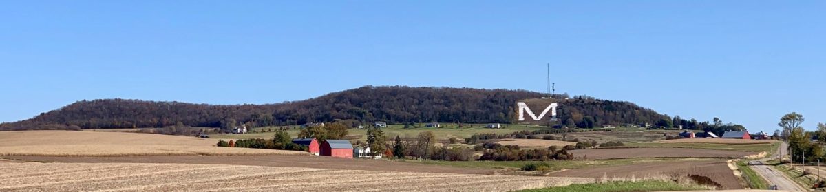
Make no mistake about it: people in tiny Platteville, Wisconsin love this Mound. It is definitely the most famous (though not the highest) of the mounds in group of mound complexes you can find in the southwest part of the Driftless Region, simply because the big “M” makes it hard to miss. In fact, the Platte Mound is featured on Platteville postcards you can buy at the Chamber of Commerce (see below). Kip Schreck took this with his Powered Parachute… now tell me that isn’t cool!
Two hundred and sixty-six of the stairs leading up to the top of the “M” have been sponsored by “M” aficionados.
But you don’t have to parachute in to get to the top of the “Big M.” Just drive to the base and walk up. Actually, it’s a great way to get in shape, and in summer, you may see the more athletic of visitors running up and down the wooden stairs: almost 300 of them, 266 of which bear the names of the sponsors that helped fund its building. From the top, there’s a spectacular view of the surrounding area.
Almost to the top of 266 stairs. (That’s counting the named ones… a few more have been added at the bottom, as some visitors tended to “slide” down the final bit of the hill if the grass was too wet!)View of the M & M farm from the top of the Mound.
So… let’s say you’ve pulled into that parking lot at the base of the “M,” and maybe you wonder why it’s there. Well, yeah, you could read the sign, but it won’t help you much… it says “the World’s Largest M” is the symbol for UW-Platteville’s College of Engineering (which would mean it should be an E, maybe?)
“The World’s Largest M,” sign at the bottom of the Platteville or Platte Mound.
But if you have someone with you who’s from around here, maybe they’ll jump in and tell you that the “M” is for “Mining,” because the part of what’s now the University of Wisconsin-Platteville that was an old mining school got into a battle with the Colorado School of Mines to see who could make the biggest “M”… back in the 1930s. But the mining engineers did build it, and current engineering students keep it whitewashed, just like it’s some alphabetic version of Tom Sawyer’s picket fence. In fact, the “M” was until recently part of UW-Platteville’s logo. But all of that is another story, one that winds back through the mining history of Platteville’s recent past. It’s a good story, though not one we’re going to hear today.
Maybe like me, you also wonder what people thought about the Mound before the miners arrived. Surely it was some sort of sacred sight. Did people live on it it? Or maybe you’ve heard stories of UFOs doing fly-bys on the mound… or maybe you just think all this storytelling is just sort of Mickey Mouse.
Guess what? You’re right (at least about the last thing)! On July 4, 1998, the big “M” lit up with Mickey between its peaks (see below). Maybe your guide was part of the Disney Hometown Parade that came to Platteville that year… or maybe they helped whitewash the Mound (especially if your guide is an engineering graduate of UW-Platteville) or danced or played with the band at the annual Miner’s Ball held at its base. Dancing in the twilight of a torch-lit giant letter may be strange, but its a lot of fun.
The Big “M” with Mickey Mouse ears, on July 4, 1998. (Why? If you’re local, probably you remember the Disney Hometown Parade. If not, come back for another article on the “M”‘s history this winter.)
But for me– not being an engineer, band member, stair runner, or even a good rock whitewasher– the real fun comes from hiking around on top of the Platte Mound and taking pictures. Since every season *but* winter is a good time for hiking, I thought I’d talk about that first, and save the history for another post this winter. So if you want to know more about the Mound’s history… I’ll get to it, but not today.
Seasons on the Mound
If you just want to see the view, summer is definitely the best time. Want to watch a beautiful sunset? The easiest direction to look from the top is west.
Sunset from the top of the M
Also, if you just want to exercise by running up and down the steps, any time where the temperature’s above freezing will do. (Trust me, you don’t want to run up those stairs when there’s any chance of ice.)
Or… if you’ve read our earlier article on the mound complexes and know how the tallest Blue Mound and Platte Mound and Sherrill Mound all line up, then maybe you want to know how to see Sherrill Mound. (After all, it doesn’t have a big letter on it to make identification easy.) Just look for the two irrigation ponds you see in the photo below, then look up to the horizon. There it is!
Here’s another view (with Sherrill Mound in the distance) except its from the base of the Platte Mound rather than the top.
That’s Sherrill Mound in the distance, on the other side of the Mississippi River.
But if you really want to explore, then take a hike on the top. The best time for that is early fall or late spring, not summer. For one thing, the foliage that grows thick during the summer months includes plenty of stickers and berry bushes–gooseberry and black raspberry, mainly–with thorns. Also, if you like the view, you won’t be able to see much through all the greenery in summer.
Once you climb the stairs to the top, you’ll be facing some ugly cell phone towers (all of the local mounds have cell phone towers on their tops, for obvious reasons–they are the highest spots in the area– though these towers really are eyesores and sometimes give off an annoying hum.)
At the top, you’ll see unlabeled yet pretty obvious paths heading right (south) or left (north). For the shortest and safest hikes, turn right. For more adventure and wilder scenery, turn left.
The Right (South) Path
From the south trail looking … of course … south. That’s West Moundview Road in the distance.
The path that heads south will give you a great view of nearby farm country, including several Amish farms which regularly advertise fresh produce through late summer and fall, and fresh eggs year-round. After you wind along the ridge for a very short while, you’ll run into various forks. Don’t worry… you can’t really get lost on this side. If you decide to go off-trail, all you need to do to find that trail again is uphill. If you stay on the gravelly top, you may actually wind up walking on to the cell phone tower service road (which used to be open, but is now locked to keep non-service-people from driving up.)
View from the south end of the Mound.
If you veer off to the right or south side (that is, if you have turned right then turn right again), and if you’re a lot taller and more athletic than I am, you’ll find several places where you can scramble up rocks that have quite an overlook, like this one to the left.
You can also get an idea of how the mounds were formed. Platteville limestone, formed by crushed invertebrates from some ancient sea, is named for this part of Wisconsin. You’ll see layers of this hard-to-erode stone that have been pushed up by even stronger geologic forces.
Some pushed-up layers of Platteville limestone on the south trail.
This limestone became the canvas for some local graffitist.
The old Nodolf residence is the subject of many excellent stories, but it is also structurally unsound. Do not go inside!
Anyway, the south ridge is the easiest to explore if you don’t have a lot of time. If you wind too far down the slope, you could actually be taking an alternate route to the bottom, but I wouldn’t. Yes, those are private residences at the bottom. But there are reasons beyond general respect for privacy that you might want to head back up rather than down.
Time for a little teaser: there’s one backyard in particular you want to be careful of not because of the owners (who are quite nice) but because the house itself is structurally unsound.
You may have heard of it, sometimes called the Platte Mound’s “Haunted House,” or written up in various accounts as the site of the “Nodolf Incident.” That’s yet another story for a different day. For now, our advice is to just stay away! Do not go inside. It isn’t safe. But it’s a fun story for some later cold, winter day… one where the mound liikes like this:
The Platte Mound in winter
We’ll leave hikers with this thought: what if, at the top of the mound, we went left or to the north instead? That’s another whole story! Be back next week with
[Editor’s note: since the Platte Mound is so heavily associated with Platteville, the most populous city in Grant County, though it’s actually across the county line in Lafayette County, we’ve tagged it for both places.]
When I moved to southwest Wisconsin 25 years ago, what first struck me were the mounds. I don’t mean the smaller conical mounds, linear mounds, or effigy mounds, though we’ll road-trip to some of those soon enough. I mean the huge hills that stand out across the landscape to such a degree that if you’re on any ridge in the Driftless Region, you likely can see one of them.
Platteville’s “M” Mound. Photo by Terry Burns.
Of course, there’s the ubiquitous Platteville Mound, above and bearing what is supposedly the world’s largest “M.” But it is only one of a huge and unexplained complex of mounds in the area. While these giant hillsides are natural formations, the “why” behind that formation– just like the “why” that this is the land the glaciers forgot– remains unknown. Most of these large mounds were sacred sites to indigenous peoples. And most obviously, they are the highest points in the area.
Charles Mound, Illinois: it may be one of the least exciting mounds in the area, but it is also the highest natural point in Illinois. Photo by Terry Burns.
For instance, Charles Mound, one of the smaller mounds but one lying in the sliver of the Driftless Region in Illinois, is the highest natural point in that state at 1,235 feet. (The highest “non-natural” point in Illinois is Chicago’s Willis Tower, at 1,450 feet.)
From almost any ridge in the Driftless area, you can see one of the larger mounds; from the top of every larger mound, you can see a smaller mound. You can actually use the mounds to navigate around the Driftless Region, if you want to. . . and pre-GPS, many people wanted to.
Belmont Mound, appropriately located in Belmont Wisconsin. Photo by Terry Burns.
Wisconsin’s first state capitol, near the Belmont Mound. Photo by Terry Burns.
For instance, the sight of one of the smaller mounds, the Belmont Mound (left), is what led settlers to create the first Wisconsin state capitol (right) almost in it’s shadow: the mound was an easy natural marker to find. Legislators actually met in one building (the one on the right) and slept in the other after they finished their business. This ended after a couple of years, when the capitol moved to Madison. Maybe legislators don’t make the best bedfellows!
If you spend as much time as we do road-tripping to different mounds, it’s hard not to start seeing connections between them, which is why I’m writing this introductory post about the “mound complex” rather than individual mounds. For instance, suppose you go to the highest spot in the Driftless Region, the top of the west end of one of the Blue Mounds.
The view north from the top of Blue Mound State Park’s west observation tower. Photo by Terry Burns.
Helpful though slightly vandalized signage at the top of Blue Mound’s west observation tower points out some of the mounds visible from this point, the highest in the Driftless Region. Photo by Terry Burns
At 1,716 feet, this gorgeous view is also the highest point in southern Wisconsin and the entire Driftless Region. From the west observation tower of Blue Mound State Park, you get quite a view of some of the other Mounds in the area (as the sign to your left shows.) You can also get an awe-inspiring view of the landscape to the north, or look east and make out the faint outlines of our current state capitol in Madison. (The isthmus upon which our state capitol sits is on yet another sacred site, but that’s a blog post for a different time!)
Some of the mounds on the borders of the Driftless Region, like Elk Mound in northern Wisconsin, actually are made by glacial debris. Many, like the Sherrill Mound over in (surprise) Sherrill, Iowa, aren’t “officially” recognized (whatever that means); others, like the previously mentioned Blue Mound and Belmont Mound (WI) are part of state parks. (Blue Mounds is plural in this sentence but not in the preceding one because only one of the blue mounds is in the state park; there’s a second “Blue Mound,” slightly shorter at 1,490 feet, in a county park nearby.)
Many of the mounds are on private property. Some owners make it clear that you’d better not trespass. Others, like the owners of Charles Mound, let people visit certain times of the year only. In some places, like in Jo Davies county Illinois, home of Horseshoe Mound, a conservation organization has collected money to protect the mound from development.
Helpful signage at Sinsinawa Mound. Photo by Terry Burns.
Sinsinawa Mound viewed from Highway 11. Don’t worry, the dinosaur in the foreground isn’t real. Welding strange monsters is just another Driftless Region hobby. Photo by Terry Burns.
The Dominican sisters at Sinsinawa Mound seem unique among mound property owners in recognizing and celebrating that these mounds likely were — or to Dominicans, are — on sacred ground. Sinsinawa’s signage points out that the native Americans who were their when Europeans arrived called it “Manitoumie,” meaning “land where the Spirit dwells,” probably a version of “Manitou.” As author Sister Mary Paynter, OP, pointed out, “It seems that manitou (or a variation) is fairly standard in the languages of native peoples who would have been in this southwest part of Wisconsin at various times– and the meaning is ‘Great Spirit’ or ‘God’ [in our Western Christian vocabulary].” Incidentally, Mary Paynter has done extensive research on the native history of the name “Sinsinawa;” we’ll look at her work more when we road-trip to the Sinsinawa Mound.
Native history in this area goes back nearly 2,000 years and involves multiple tribes, including the Fox, Sauk, Anishinaabe (Ojibwa), Ho-Chunk (Winnebago), Potowatomi, Dakota, and Mesquawki. This writer is not surprised that the lone native reference I can find to what native people called one of the mounds confirms that they saw at least one of them– and my guess would be all of them– as a sacred place.
One might easily guess that the abundance of smaller and definitely human-made mounds (the conical, linear, and effigy mounds which occur throughout Wisconsin but especially in the Wisconsin River valley in greater density than anywhere else in North America, and which make up Effigy Mounds National Monument in Iowa) might be also indirectly related to the lack of glaciers… yet almost all of those were made AFTER the surrounding ice melted. The larger mounds that are the subject of this article are much older: 10,000 years old as a minimum. Some of them, like the smaller mounds, look terraformed. Could they also have been made by native peoples? I’m no geologist, but my friend Dr. Rich Waugh is, so I decided to get the scoop from him. Did humans make these mounds?
The large mounds in southwest Wisconsin, Waugh says, were “most definitely made by natural forces, primarily erosion related to streams and slope processes.”
“None of this precludes human use of the Mound,” Waugh added. ” I would be amazed if Native Americans didn’t impart some meaning to the Mound.”
These huge hills are often pocked with caves and natural springs. They make for great hideaways, too! In my next post, I’ll show you one of my favorites, on the Platte “M” Mound.
Before I end this installment, though, I do want to suggest that these large mounds are more than haphazard markers on the landscape. They’re upwellings of geological energy and follow patterns. As my husband Alan and I road-tripped to more and more of the large mounds, we’ve noticed relations between them not often taught in local schools.
For instance, Alan noticed that the Blue Mound, Platteville Mound, and Sherrill Mound all line up exactly.
Sherrill Mound (IA), Platteville’s “M” Mound (WI) and the first Blue Mound (WI) all lie on the same ley line. Thanks to J. Alan Moore for pointing this out.
From the top of one, one a clear day, you can see the next one. That is, from the top of the Blue Mound’s west observatory tour (as noted in a graphic earlier), you can see the Platte or Platteville Mound (and know that, lined up behind it on the other side of the Mississippi River is the Sherill Mound. From the Platte Mound, you can see the Sherrill Mound. And from the Sherrill Mound (see below) you can see the Platteville Mound (and know that, lined up behind it, is the tallest of the Blue Mounds.
Platteville Wisconsin “M” Mound as seen from Sherrill Mound, Iowa (with the help of telephoto 10x!). Photo by Terry Burns.
Summer solstice marker at the top of Horseshoe Mound. The zoomed-in photo below, showing Sherrill Mound and Balltown Iowa in the distance, was taken from this location. Photo by Terry Burns.
The Blue Mound-Platte Mound-Sherrill Mound line isn’t the only one. Several years ago, conservationists in Jo Davies county Illinois opened up the Horseshoe Mound for viewing. Clearly the people who designed the new park knew the mound well, and had watched natural phenomena on it for years, because on the top they’ve created a round circle showing where on the horizon the sun rises and sets on the winter and summer solstices. Turns out, the sun sets right between Iowa’s Sherrill and Balltown mounds. To the right, you can see the view with the naked eye, but below is what it looks if you zoom in. We thought it was pretty cool how the conservationists in Jo Davies county set things up so that you have a variety of views labeled, in a sundial-like pavillion.
View from Horseshoe Mound, with Galena, Illinois in the foreground. In the distance, you can see across the Mississippi river to both Sherrill Mound (right) and Balltown, Iowa (which also sits upon a mound.) On the summer solstice, the sun sets right between those two points on the horizon. If the view extended further to the right, you’d also see Sinsinawa Mound, Wisconsin. Photo by Terry Burns.
Signage on Horseshoe Mound pointing out what you can see in the distance
You can draw similar geographic connections between some of the smaller mounds. And yes, right now I’m mainly writing about the mounds nearest to me… I haven’t moved very far north at all. For instance, so far, I’ve totally ignored the Minnesota Driftless Region, though I will get to that eventually.
But for now, let’s start day-tripping! First stop: the Platte “M” Mound.