The City of Presidents!

Experience the grandeur and prestige of Cuba City’s heritage

Lincoln sign
Along Cuba City’s main drag, one sees silhouettes of every U.S. President. The red, white and blue shields also include the state that person was born in, the years he served, and the which “number” President he was.

In the deep north of America’s bread basket lies a tiny town of about 2000 people called Cuba City, Wisconsin. The town is nestled snugly between the bustling and collegiate Platteville metropolitan area (pop. 11,000) and a cluster of even smaller towns like Hazel Green, WI (pop. 1256) to the south and Dickeyville, WI (pop. 1060) to the west. The town is fundamentally a strip of road lined with businesses which are surrounded on both sides by a grid of single story houses that stretches for a half mile outward in all directions.

Cuba City Welcome Sign
Cuba City’s welcome sign

Along this strip of Highway 80, one immediately notices the signs with silhouettes of U.S. Presidents: all of the U.S. Presidents. One may also soon see the focal point of this, the main strip of Cuba City’s main street: a tourist attraction called the “Presidential Courtyard,” a monument to the city’s nickname, “The City of Presidents.” Cuba City is a time capsule of small town America filled with relics from the Cold War age of patriotism.

Presidential Courtyard rock
Part way through the main strip, you’ll see this rock marking the “Presidential Courtyard,” or the related red caboose pictured below. Photo by Jacob “Vinny” Klang.

Questions about the naming of Cuba City are so common that many shops have hung signs explaining how the city got its name. Every store, retailer, and restaurant has these signs which are written by the city, perhaps to help visitors get more confused.

Cuba City History Questions Sign
Some storeowners have put up signs to let visitors know how Cuba City became known as the “City of Presidents.” Photo by Jacob “Vinny” Klang.

Around town there is a theory regarding the evolution of the town’s name:  the town was originally “Yuba City” but since there was already a “Yuba” in Richland county, “Cuba” was chosen as an alternative.

How did “Cuba City” then become the “City of Presidents”? Let’s start there and work our way backwards to the presidential signs.

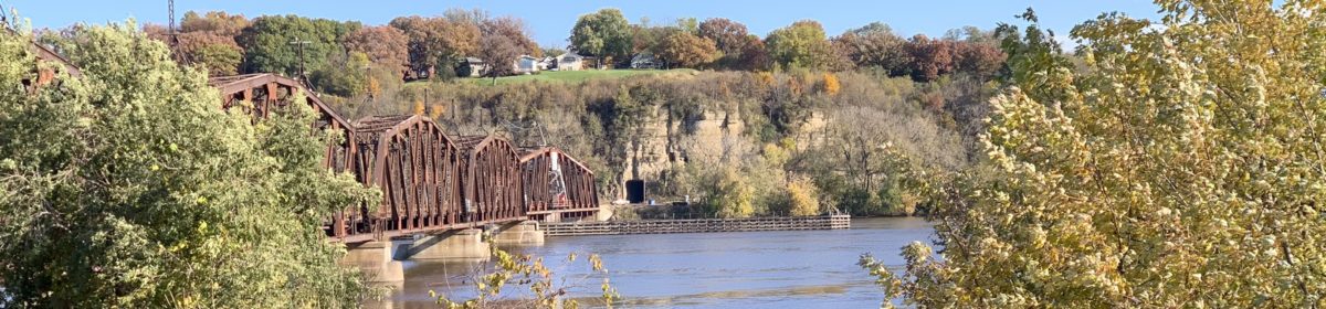
The official title was chosen in 1993 when the city’s common council changed the slogan from the “Parade of Presidents” by popular vote. But the patriotic naming scheme started in 1975 when the village was preparing to celebrate the United States Bicentennial Anniversary. The titular parade referred to plywood sigils featuring those silhouettes of every American president referred to earlier, which were and are still hung on every lamp-post along Cuba City’s main street. The sigils have since been replaced with durable weather proof plastic, and joined by the “Presidential Courtyard” near the center of the strip, one I’ll talk more about in a moment.

Presidential Caboose
Presidential Caboose sits in the Presidential Court yard. Grant County, Wisconsin (where Cuba City is located) is named after President Ulysses S. Grant.

All of those signs seem like a lot of work for the 1976 Bicentennial Celebration, especially for a town of 2000 people. One theory about why the town leaned into such heavy participation in the bicentennial was that they wanted to ward off any suspected affiliation with communist Cuba. At that time in global politics, Cuba was a bastion of socialist thought and was the source of a much anxiety in the American consciousness (and had been so since the Bay of Pigs in the early 1960s.). Having this unpatriotic tie to Cuba would not have been good for the city’s tourism so they may have doubled-down and made a very American tourist attraction to counteract this association.

Is this true?  One retired history professor commented that she had also heard this speculation, as had the editor of this blog.  But neither could link it to documentary evidence, so a speculation it remains.  In any case, since the original presidential signs in the 1970s, the idea has taken on a life of its own.

Since then, the Presidential Courtyard has been built upon a patch of grass along Main Street where the sigils ended. But of course more presidents have been added to the parade since the late seventies so the courtyard is now about two-thirds down the street.


The best and easiest way to experience the displays is to drive into town and park along the main street near the edge of town where you can casually walk the stretch of road at your own pace. There are benches to rest on along the way and plenty of shops and bars to sit or get distracted in. If you’re worried about parking on a busy street you can park in the residential neighborhoods for the same effect (remember to note what street you’re on so you can find your way back later). For the travelers short on time there is also a free and public parking lot at the Presidential Courtyard itself.


By the time you’ve soaked in the sights, sounds, and smells of the flowers you’ll find yourself back at the “Presidential Courtyard.” This courtyard was assembled from scratch in 2006 as an addition to the Parade of Presidents and it contains a bright red train caboose, several potted plants, informative signs, and a stray cat with a tuxedo pattern on its fur.

clock
Refurbished Cuba City State Bank clock which contains a time capsule scheduled to be opened in 2056. Photo by Jacob “Vinny” Klang.

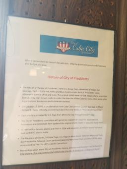
As you enter the courtyard from the front you will notice a large refurbished clock hanging above you like it has hung over Cuba City since its construction. Inside the clock is a time capsule made by the Cuba City high school and is scheduled to be opened on the 50th anniversary of the courtyard’s construction in 2056.

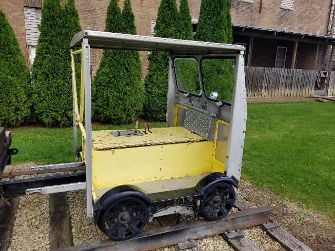
The train caboose is a refurbished and well maintained train car. Along with the portrait of Ulysses S. Grant, one sees a variety of informational signs. Next to the train on the same track is a utility cart with a display of railroad tools. Opposite the track is a gazebo optimized for family picnics and a few benches, all of which have more signs for visitors to learn from.


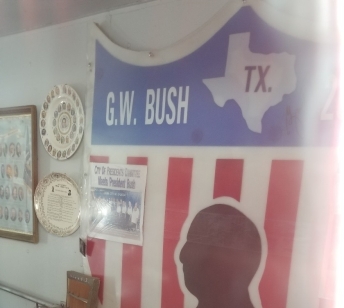
The caboose acts a mini-museum of presidential history. Also, one of the presidential sigils hangs here in the corner instead of on the street: the one with a silhouette of George W. Bush, the only U.S. president to actually visit Cuba City. President Bush signed it when he visited in October of 2004.

A leading figure in Cuba City, Joe Goeman, explained that it was “one of the biggest things to happen to Cuba City [when] the president came to visit. Of course, that didn’t happen by itself. We had people write to the presidents for several years until finally it happened.”

bush sigil
George W. Bush presidential sigil replica housed in Presidential Courtyard Caboose signed by former president George W. Bush. Photo by Jacob “Vinny” Klang.

The rest of the caboose has displays of memorabilia from presidential campaigns and other Americana. The caboose is open to the public on Saturdays between Labor Day and Memorial Day and also on the third Wednesday of every month or by appointment.

Behind the caboose is a smaller car called a “Speeder Car” which has a tray of tools hitched to the back. The speeder car adds depth to the train display by showing the variety of tools needed to build and maintain a train network and implying the hard work and skill needed for America to have such powerful industry. Opposite the speeder car is a milk trolley with a trio of vintage milk canisters on one side. The milk trolley has plenty of room for visitors to climb up on and take photos as a family. The milk trolley is included as part of Wisconsin’s history of milk processing.

tool cart
The tool cart outside of the Presidential Courtyard. Photo by Jacob “Vinny” Klang.

This location is a fun place to visit firstly as a relic of 1970’s patriotism, secondly as a testament to Cuba City’s talent of maintaining public works projects, thirdly as a unique slice of Midwestern culture, and lastly as a unique place to discover by oneself or as a group of domestic explorers.

Forgotten Works: Driftless Books and Music

“The most eclectic bookstore in southwest Wisconsin”

Just past the Wisconsin River settled in one of the crests of the Driftless area hides the small town of Viroqua. Along main street, visitors can find small local shops which each exhibit their own sense of rural charm including Gary’s Rock Shop and the Ewetopia Fiber Shop. The Driftless Café is a favorite among the locals as the perfect family oriented environment to grab a bite to eat.

Scenic views on the drive out to Viroqua, WI from Platteville, WI

However, if you stray from the main drag you might run into what appears to be the old, abandoned industrial side of this rural Wisconsin town. Among the vintage style buildings rests three old, brick tobacco factories.

Forgotten works original tobacco company
“Forgotten Works” entrance shows its history as a tobacco company.
Contemporary entrance
The “Forgotten Works” factory, also known as Driftless Books and Music

One of these factories (which has been lovingly renamed “The Forgotten Works” factory) hosts an eclectic used bookstore known as Driftless Books and Music. This brain-child of owner Eddy Nix invites visitors in with an engraved stone that hangs above the door. It reads “This is the entrance to the forgotten works. Be careful. You might get lost”.

Stone sign
Stone engraving that hangs above the door to Driftless Books and Music.

Storeowner Eddy Nix grew up in La Crosse, Wisconsin, just up the road from Viroqua. After graduation, he had the itch to travel and get out of town. So, he took the opportunity to travel to South Africa with a Rotary International program. In his own words, his experience “…was fascinating” (Nix, 2016). After the program, Eddy spent the next era of his life exploring Europe, South America, and “…places like that” (Nix, 2016). In the mid-‘90s, this world traveler had started to miss his home here in Wisconsin. He explains that all of his travels made him realize and appreciate the uniqueness and beauty that can only be found here in the Driftless region.

He began this new chapter in his life by opening a used bookstore in Viola, Wisconsin inside an old post office building. After a hail-Mary eBay search where he typed in “bunch of books,” Eddy came across an auction that was listed in the wrong category, simply titled “50,000 books.” He drove out to Connecticut and spent three months sorting through and packing up two semi-trucks full of books that were otherwise going to be thrown in the dump. When Eddy returned to Wisconsin. he began the process of unpacking and organizing.

He said “It literally took four or five years. It was like a giant Tetris game” (Nix, 2016). However, after flooding and tornadoes, Eddy knew he had to start looking for a new home for all his books.

Inside Forgotten Works
Inside Driftless Books and Music

The perfect opportunity seemed to fall into this store owner’s lap. A local philanthropist, who was also a regular in the store, was in possession of an old tobacco warehouse that was not in use. In an article published by the Minnesota Skinny, Eddy explains that “This guy saw what we were doing. He gave it to me as a challenge to make this thing real” (Haataja, 2018). He believed in Eddy’s vision and pushed him to make it a reality. This was a true case of things just falling into place.

Viroqua historic district
Sign announcing Viroqua historic district

When I visited the store this fall, I asked Eddy if he ever had a moment of “What did I get myself into?” to which he replied, “Plenty”. He said that he had a lot of questioning moments throughout his journey. Specifically, moving his business into the old tobacco warehouse became a thing of his nightmares. The building itself was old and challenging. The steam heating system was broken and did not function the way Eddy needed it to. He soon realized that he would go broke during the brutal Wisconsin winters just trying to keep the building comfortable.

So, Eddy improvised.

For the three coldest months, he closes the shop and gives himself a much-needed vacation while also giving himself some time to take books home to organize and catalog. Eddy explained that he has found through his experience that “What seems like a crisis can actually be an invitation”. He said that these moments gave him time to step back and reevaluate the situation before moving forward.

chair of books
Some gardening books in search of a new home

I remember how, on my first visit to this unique place, I stepped underneath the engraved stone warning at the entrance and was instantly overwhelmed with a sense of nostalgia. The entrance hall is lined with bins of music records which all reminded me of an old shop in my hometown that my friends and I frequented in high school. But I wasn’t even in the bookstore yet. As I passed through a second door I felt that wave of past memories pull me down further. In front of me was a room, packed floor to ceiling with books. Hundreds of books. And in the middle of the room, a couch and table for guests to find a good read, take a seat, and become lost. From behind a stack of books a friendly face appeared and greeted me.

FW entrance
Books waiting sorting

Eddy Nix makes time to stop and welcome all who come to The Forgotten Works with a happy “Hello” and a friendly smile. Whether he is working on sorting through donated books, organizing and placing more titles out on the floor, or busy packaging up pieces ever so gently in recycled brown paper bags to be shipped to customers from his online business, he is never too busy to offer his assistance. When I returned to Driftless Books and Music, I watched as two ladies wandered in to be met with the same upbeat greeting that I had.

More books
More books!

One of the ladies happened to be holding what looked like a grocery list of books written on a folded post-it. The two women told us that they were just looking around, but more specifically were interested in checking out the romance novels. One of them mentioned a specific author which Eddy thought over for a minute before directing them to the romance section and saying that he thought he might have some, if not by that author, a few that were similar in the basement. He proceeded to the lowest level which housed just as many books as the main level and effortlessly found the shelf he was looking for. I watched with a sense of awe as he scooped up the books. In a building that holds over half a million books, it takes some crazy organization and memory to remember where certain titles are resting.

Still more books
Still more books…

If you move further into the brick structure, you will pass through yet another doorway into an even larger room with, you guessed it, more books. If you don’t get lost among the tree covered hills and valleys of the Driftless area, you will get lost in the maze of bookshelves at this hidden gem.

I perused the shelves, unsure exactly what I was looking for, until I finally settled for the “self-help” section. The bookshelves were arranged to form small cubby areas with seating for visitors to use while looking for the perfect match. I started with the top shelf and skimmed for interesting titles. My hand worked its way across all of the bindings until I found myself sitting crisscross applesauce on the wooden floor.

Memory lane books
Old books take you down memory lane.

I opened the cover of the first book that I had pulled out and set aside and felt myself going back in time. Back to the moment when I was much smaller and felt myself fall out of love with reading. My mom had brought me to a small used bookstore in Bismarck, North Dakota. By the time we left, I had a stack of new-old novels and a new spark for reading.

When I sat down to talk with Eddy about the bookstore and his journey, I could feel a real sense of love and appreciation for the store and all of the visitors who stopped by. He told me that he enjoys visiting and listening to the guests who just come to visit the old building because of its tobacco history. He explained that almost every week a guest comes with their family and a story about how their grandfather or other family worked in the building or were one of the farmers who would drop off their tobacco crop at the side door which is now kept open to help with circulation.

Eddy explained to me that the tobacco industry brought families together to work with one another which is something that is just not as common nowadays. I really could feel a sense of pride from Eddy that he gets to hear and be a part of those stories. I could tell that he appreciates that history and enjoys helping it to continue to live on.

Children's reading area
A homey-feeling children’s reading area.

Another visitor entered the store with two boxes of books that he wanted to donate. They were his grandmother’s who had recently been moved into the nursing home. After the visitor left, Eddy sat down on one of the couches to start sorting through the new treasure. The first book he pulled out, no joke, was titled Say No to Nursing Homes.

We laughed and continued on. He found an old high school textbook which he set aside and explained that he was going to donate to a local high school that was looking for textbooks to use as props in an upcoming play. As he was paging through another book from the pile he found a folded grocery store ad that appeared to have been used as a bookmark some time ago. “Biblioscat” he called it.

Eddy said he feels as though he is “tending to a part of a person” when he goes through donations like this. While going through donations he has found signatures of loved ones who have passed, among other treasures that mean a lot to families. In one case, Eddy sent a book to the family of the author who did not have a copy for themselves. He told me that going through each box feel like “fulfilling a mission. It’s like a treasure hunt.”

Tables of books
Walking back towards the entrance

In addition to the sense of adventure, appreciation, and overall wonder, an underlying passion and message lays between the pages of this place. Every year, Eddy pointed out, “approximately 300 million books get thrown in landfills.”

Unwanted, these are used books that people just don’t know what to do with. These texts sit and take up even more space in our growing landfills. The way the printing industry is set up, books are published in mass production, way more than actually are purchased by individuals. Therefore, there is a surplus of books that bookstores often do not know what to do with and libraries do not have the capacity to take in. These books often simply get tossed out along with the other used books that individuals have read and don’t know what else to do with. Eddy explained that this is often an overlooked issue: if you think about it “some titles are going extinct as fast as species.”

Books not landfill
Eddy has saved many books so their joy can be passed on to others.

Driftless Books and Music gives a home to these used books and functions as a place where people can save these titles for others to enjoy for years to come. Anyone can donate their used books to Eddy who will in exchange offer some in store credits or even sometimes cash.

This way, donors can then peruse the store in search of a new read. Unless the book has signs of mold, Eddy finds a place in the vast brick building to put the piece of work until it is rediscovered. In Eddy’s words, “Who am I to judge which books should be kept and which ones tossed?” He further explained that although a title might not be the kind of book that he would personally pick up for enjoyment, he finds it fascinating what each item in his store is worth to different people. Whether it be for the family history or just that they find that particular item meaningful.

inside of shop
One last look at the inside of Driftless Books and Music… until the next visit!

A more recent goal of Eddy’s is to help expand used bookstore connections to help save the books from the landfill graveyard and to encourage younger people to pursue this as a career option. He hopes to start a co-op where used bookstores can network with each other and libraries to create a much-needed support system. Eddy hopes he can use technology for his benefit to help this network organize the titles they possess most effectively. He also hopes it will help readers find the title that they are looking for easier.

Eddy said that he has always seen bookstores as this type of cultural intersection. They provide a social area that brings communities together in a supportive and safe environment. He explained that he hopes that this place leaves his visitors with a sense of ontological questioning or a feeling that just makes them pause and really think and reflect. Whether visitors stop by in pursuit of a specific title, to browse the shelves, or to reminisce on the history of the location, this attraction is guaranteed to be a memorable stop. As I traveled home through the Driftless hills, I couldn’t help but feel like the world could use a few more repurposed tobacco warehouses and a few more Eddys to lead them.

To read more about Eddy’s story and Driftless Books and Music, check out the following articles and follow Driftless Books and Music on Facebook using the links below:

http://realsmalltowns.com/eddy-nix/

https://www.lovewi.com/eddy

https://www.facebook.com/DriftlessBooks/

References:

Haataja, F. (2018, April 27). Chapter 5: Driftless Books and Music in Viroqua, Wisconsin. Retrieved September 25, 2019, from http://minnesotaskinny.com/2018/04/27/driftless-books-viroqua-wisconsin/.

Nix, E. (n.d.). “The guy who owned this old tobacco warehouse here in Viroqua, he just gave me the building. Just gave it to me.”. Retrieved September 25, 2019, from https://www.lovewi.com/eddy.

Winding North to Vernon County

Vernon county
Vernon County, Wisconsin, from Wikipedia commons

We can’t spend all of our road trip in one corner of southwest Wisconsin! So today, we’re going to wind north to Vernon County, home of a plethora of state and county parks. One of them, Wildcat Mountain (are those some mounds, or what?) also doubles as a ski resort. It’s also home of the 8600 acre Kickapoo River Reserve, a valley along the largest tributary to the Wisconsin River and a truly spectacular wildlife and canoeing spot. As DriftlessWisconsin.com points out, “[b]ecause the glaciers that missed the Driftless Area did not change its natural course, the Kickapoo River Valley is one of the oldest river systems in the world.”

We’ve always liked driving through Vernon County– any part of Vernon County.

The county’s top industry happens to be organic farming. They’re also home of the world’s largest cooperative of family farms, Organic Valley, whose main distribution center is almost totally solar-powered.

The Organic Valley headquarters in LaFarge, Wisconsin.
Signage from the “Uff-Da Shoppe” in Westby
The U.S.A.’s oldest tobacco cooperative isn’t out east, like you might think. It’s in Viroqua, Wisconsin. Photo by “Appraiser.”

Co-ops are a way of life here, as is preserving a sustainable local heritage. Want some cool Scandinavian gifts? Stop into little Westby’s “Uff-Da-Shoppe”! Or drive on to the county seat, Viroqua, whose population doesn’t quite break 5,000. Along with a health-food coops, they also are home to the nation’s oldest tobacco-growing cooperative.

Rachel Eckmann

But as we told you on our submissions page, we’re word nerds here. And it just happens that little Viroqua is also home of one of the coolest bookstores we have ever seen! It’s also time to introduce our first guest writer, Rachel Eckmann. Welcome, Rachel!

Driftless Books and Music: The Most Eclectic Bookstore in Southwest Wisconsin

The Platte Mound II

This is a continuation of last week’s article on the Platte or Platteville “M” Mound.

Platteville Mound
Platteville, Wisconsin postcard from the Platteville Chamber of Commerce. You can see the football stadium and dorms from the University of Wisconsin-Platteville in the mid-ground and parts of the city of Platteville interspersed through the trees… and of course, that’s the world largest “M” in the distance. Low resolution of ©photo by Kip Schreck used per fair use law; no reproduction for profit allowed. Postcards available at the Platteville Chamber of Commerce office.

Last week, we looked at some of the beautiful views and took a walk down the south ridge. But the real fun lies to the north!

Caves, Crevices and Campfires

If you’ve made it to the top of the mound for a hike, the north path is a lot longer and, to me, more fun. If you go, take a compass (or make sure you know how to use the one on your cell phone!) Unlike the easier south path, this trail is one you can get lost on.

You’ll spend the first quarter-mile just walking along the ridge, but the trail is fairly well-marked for this first little bit. Eventually you’ll be under the trees… just stay on the trail!

north trail of the mound
Even once you get in the woods, the trail is fairly well marked.

“Stay on the trail.” Sounds like an easy concept to follow, right? But if you’re like most of us, pretty soon you’ll notice that more of the coller-looking things — ravines, jutted up rock formations, climbable treefall, views of “the other side of the mound” — all lie off to the right (or east), which is also where its easiest to get lost. But after all, you did bring a compass and cell phone, so…. pretty soon, in spite of yourself, you may find yourself tempted off-trail!

north trail 2
The trail will lead you past lots of fun hide-aways.

north trail 2
… and past lots of “rockfall” …

mound cave
Sometimes you even find some cave-like hiding places. But that’s only if you’ve given into temptation and left the main trail.

When you get to the far north end of the trail, you’ll see how the Mound ridge has narrowed. Any time except late summer, you’ll have a view off to the north. There’s almost always some sort of campfire pit there. Recently, a local rock artist built this little pyramid!

North end.
The north end of the Platte Mound in winter.
ridge view
One the other side of this particular ridge, you can see nearby Belmont Mound.

Remember how I told you in the last article how you could see Sherrill Mound from the Platte Mound? Well, you can also see the Belmont Mound, if you walk off the trail far enough to the east and find a high ridge. You just can’t get the best picture through the trees. There’s also another little mound (literally called “Little Mound”) that sits half-way between them.

icicles
Icicles on the north trail, from early November 2019

If you’re lucky enough to take your hike just after a freeze (but when things have thawed enough on the sunnier side next to the “M” that you can get up the stairs), you’ll find all sorts of cool icicles, dripping out of the limestone. That’s because 1) it stays colder up in the shade, obviously, and 2) Since limestone is very porous, water easily flows out of its crevices and makes icicles. (You’ve probably seen this same phenomenon on highways, where a road has been blasted through limestone. In winter, it seems to spew icicles faster than the surrounding area.) They’re a lot of fun to see!

Now for the anticlimax…

You can hear all sorts of local stories about different caves up on this trail. Some people swear there really aren’t any. They’re either lying to you or didn’t look very hard. I’ve been in a couple of these caves and listened to stories over beer about lots of others. True, some of the stories were crazy-sounding (like the guy who used to sit at the old Ed’s Cafe and opine that their were Egyptian hieroglyphics inside the mound somewhere). Others, like the story of a child who fell into on of the caves many years ago resulting in that cave being sealed off (either with concrete or by dynamiting it), can’t be easily proven true or false.

But there ARE many places visited not just by me but by seasoned spelunkers with hard-hats, lights and lines. I won’t be the one to tell you how to get to them. Any cave beyond the size of the one shown earlier in this article is a place you shouldn’t go into without someone who knows what she’s doing . . . and that person is not yours truly.

But I can tell you some brief stories about them,

One of the caves, reports long-time resident Garry Prohaska, is more than thirty feet long. Another has multiple rooms. How many caves does the Platte Mound house? Well, retired professor Tracy Roberts has pointed out that the Mound’s limestone ravines, and the way they were formed through stream erosion, suggests that there likely are many unseen sunken caves where water has already created a crevice. That cave-making process takes literally thousands of years: one property of limestone is its ability to maintain its structural integrity for a very long time. There’s no record anyone has made of where the caves are (though you can find Facebook discussions where some locals are telling others to keep quiet about the locations!) But chances are pretty high that, if someone was in a cave 20 years ago, it’s still there, though perhaps covered with surface debris.

Another long-time Platteville resident, now sadly deceased, once described how to get into his favorite cave. Luckily for us, he did it in general enough terms that you can get an idea of the process but not actually locate the cave.

He reported, “if you go into that crawl space [under a particular rock] you’ll get into a small room. [Shine your flashlight] to the left and look for a crack. Crawl on your belly through the tunnel, spiral down to the right, and when you are able to get off your belly, climb down and you’ll have room to stand up. Move slowly to the left, and there’s a second entire room.”

By the way… caves like this pockmark the Driftless Region, especially wherever you find ravines and limestone. But you’ll need to find someone else to show them to you. My time wriggling through rocks belonged to a younger, thinner, and slightly crazier version of myself. My advice is to just enjoy the hiking… that’s beautiful enough!

One last story though… here a (very) old road trip story from a preacher’s journal about one particularly large cave somewhere in the mound (Thanks to my friend Laurie Graney for locating this article. It’s from November 26, 1835, and the various spelling mistakes are from the original.)

A Methodist Circuit Rider’s Tour

West Platt mound. Preached at night. This mound with its mate 3 miles east of it, rises 200 feet above the common levil of the country. They are each about a mile in circumference, & mostly covered with timber. The west one has in it a cave which has been explored 1[oo] or 200 yards [in], & after winter set in a rattlesnake was found crawling about as in summer.

Wisconsin Historical Collections Volume XV. “(1835 ) A Methodist Circuit Rider’s Tour. “

Do any of the caves really go in 100 or 200 yards? I don’t know. It’s fun to think so!

All right, I guess the least we could do is show you an old hideout or two. These places, all off of the east side of the trail (the side towards Belmont Mound), are all safe and easily hiked through. Sometimes you notice that folks have been camping there. The Boy Scouts used to, but now and then older folks do, too.

Walking the ridge
Walking just below the ridge of the mound in fall, you are bound to find something.

[Editor’s note: since the Platte Mound is so heavily associated with Platteville, the most populous city in Grant County, though it’s actually across the county line in Lafayette County, we’ve tagged it for both places.]

Check out this topo map of the Platte Mound!

We’ll be back with more on the Platte Mound and its history after winter comes! Now let’s head north to Vernon County, Viroqua, and a great bookstore….

Unless noted, all photos by Terry Burns

Tell us about your favorite place in the Driftless Region!

The Platte or Platteville “M” Mound

Make no mistake about it: people in tiny Platteville, Wisconsin love this Mound. It is definitely the most famous (though not the highest) of the mounds in group of mound complexes you can find in the southwest part of the Driftless Region, simply because the big “M” makes it hard to miss. In fact, the Platte Mound is featured on Platteville postcards you can buy at the Chamber of Commerce (see below). Kip Schreck took this with his Powered Parachute… now tell me that isn’t cool!

Platteville, Wisconsin postcard from the Platteville Chamber of Commerce.    You can see the football stadium and dorms from the University of Wisconsin-Platteville in the mid-ground and parts of the city of Platteville interspersed through the trees... and of course, that's the world largest "M" in the distance.  Low resolution of ©photo by Kip Schreck used per fair use law; no reproduction for profit allowed.
Platteville, Wisconsin postcard from the Platteville Chamber of Commerce. You can see the football stadium and dorms from the University of Wisconsin-Platteville in the mid-ground and parts of the city of Platteville interspersed through the trees… and of course, that’s the world largest “M” in the distance. Low resolution of ©photo by Kip Schreck used per fair use law; no reproduction for profit allowed. Postcards available at the Platteville Chamber of Commerce office.
M from parking lot
The “Big M” from the parking lot.
Stairs up the mound with names
Two hundred and sixty-six of the stairs leading up to the top of the “M” have been sponsored by “M” aficionados.

But you don’t have to parachute in to get to the top of the “Big M.” Just drive to the base and walk up. Actually, it’s a great way to get in shape, and in summer, you may see the more athletic of visitors running up and down the wooden stairs: almost 300 of them, 266 of which bear the names of the sponsors that helped fund its building. From the top, there’s a spectacular view of the surrounding area.

From the top of the stairs
Almost to the top of 266 stairs. (That’s counting the named ones… a few more have been added at the bottom, as some visitors tended to “slide” down the final bit of the hill if the grass was too wet!)
View from the top
View of the M & M farm from the top of the Mound.

So… let’s say you’ve pulled into that parking lot at the base of the “M,” and maybe you wonder why it’s there. Well, yeah, you could read the sign, but it won’t help you much… it says “the World’s Largest M” is the symbol for UW-Platteville’s College of Engineering (which would mean it should be an E, maybe?)

World's Largest M
“The World’s Largest M,” sign at the bottom of the Platteville or Platte Mound.

But if you have someone with you who’s from around here, maybe they’ll jump in and tell you that the “M” is for “Mining,” because the part of what’s now the University of Wisconsin-Platteville that was an old mining school got into a battle with the Colorado School of Mines to see who could make the biggest “M”… back in the 1930s. But the mining engineers did build it, and current engineering students keep it whitewashed, just like it’s some alphabetic version of Tom Sawyer’s picket fence. In fact, the “M” was until recently part of UW-Platteville’s logo. But all of that is another story, one that winds back through the mining history of Platteville’s recent past. It’s a good story, though not one we’re going to hear today.

Maybe like me, you also wonder what people thought about the Mound before the miners arrived. Surely it was some sort of sacred sight. Did people live on it it? Or maybe you’ve heard stories of UFOs doing fly-bys on the mound… or maybe you just think all this storytelling is just sort of Mickey Mouse.

Guess what? You’re right (at least about the last thing)! On July 4, 1998, the big “M” lit up with Mickey between its peaks (see below). Maybe your guide was part of the Disney Hometown Parade that came to Platteville that year… or maybe they helped whitewash the Mound (especially if your guide is an engineering graduate of UW-Platteville) or danced or played with the band at the annual Miner’s Ball held at its base. Dancing in the twilight of a torch-lit giant letter may be strange, but its a lot of fun.

The Big "M" with Mickey Mouse ears.
The Big “M” with Mickey Mouse ears, on July 4, 1998. (Why? If you’re local, probably you remember the Disney Hometown Parade. If not, come back for another article on the “M”‘s history this winter.)

But for me– not being an engineer, band member, stair runner, or even a good rock whitewasher– the real fun comes from hiking around on top of the Platte Mound and taking pictures. Since every season *but* winter is a good time for hiking, I thought I’d talk about that first, and save the history for another post this winter. So if you want to know more about the Mound’s history… I’ll get to it, but not today.

Seasons on the Mound

If you just want to see the view, summer is definitely the best time. Want to watch a beautiful sunset? The easiest direction to look from the top is west.

Sunset from M Mound
Sunset from the top of the M

Also, if you just want to exercise by running up and down the steps, any time where the temperature’s above freezing will do. (Trust me, you don’t want to run up those stairs when there’s any chance of ice.)

Or… if you’ve read our earlier article on the mound complexes and know how the tallest Blue Mound and Platte Mound and Sherrill Mound all line up, then maybe you want to know how to see Sherrill Mound. (After all, it doesn’t have a big letter on it to make identification easy.) Just look for the two irrigation ponds you see in the photo below, then look up to the horizon. There it is!

Sherril Mound
Here’s another view (with Sherrill Mound in the distance) except its from the base of the Platte Mound rather than the top.
Sherrill Mound in the distance
That’s Sherrill Mound in the distance, on the other side of the Mississippi River.

But if you really want to explore, then take a hike on the top. The best time for that is early fall or late spring, not summer. For one thing, the foliage that grows thick during the summer months includes plenty of stickers and berry bushes–gooseberry and black raspberry, mainly–with thorns. Also, if you like the view, you won’t be able to see much through all the greenery in summer.

Once you climb the stairs to the top, you’ll be facing some ugly cell phone towers (all of the local mounds have cell phone towers on their tops, for obvious reasons–they are the highest spots in the area– though these towers really are eyesores and sometimes give off an annoying hum.)

At the top, you’ll see unlabeled yet pretty obvious paths heading right (south) or left (north). For the shortest and safest hikes, turn right. For more adventure and wilder scenery, turn left.

The Right (South) Path

Mound scenery from south trail
From the south trail looking … of course … south. That’s West Moundview Road in the distance.

The path that heads south will give you a great view of nearby farm country, including several Amish farms which regularly advertise fresh produce through late summer and fall, and fresh eggs year-round. After you wind along the ridge for a very short while, you’ll run into various forks. Don’t worry… you can’t really get lost on this side. If you decide to go off-trail, all you need to do to find that trail again is uphill. If you stay on the gravelly top, you may actually wind up walking on to the cell phone tower service road (which used to be open, but is now locked to keep non-service-people from driving up.)

South view
View from the south end of the Mound.

If you veer off to the right or south side (that is, if you have turned right then turn right again), and if you’re a lot taller and more athletic than I am, you’ll find several places where you can scramble up rocks that have quite an overlook, like this one to the left.

You can also get an idea of how the mounds were formed. Platteville limestone, formed by crushed invertebrates from some ancient sea, is named for this part of Wisconsin. You’ll see layers of this hard-to-erode stone that have been pushed up by even stronger geologic forces.

Platteville limestone
Some pushed-up layers of Platteville limestone on the south trail.

graffiti
This limestone became the canvas for some local graffitist.
the old Nodolf house
The old Nodolf residence is the subject of many excellent stories, but it is also structurally unsound. Do not go inside!

Anyway, the south ridge is the easiest to explore if you don’t have a lot of time. If you wind too far down the slope, you could actually be taking an alternate route to the bottom, but I wouldn’t. Yes, those are private residences at the bottom. But there are reasons beyond general respect for privacy that you might want to head back up rather than down.

Time for a little teaser: there’s one backyard in particular you want to be careful of not because of the owners (who are quite nice) but because the house itself is structurally unsound.

You may have heard of it, sometimes called the Platte Mound’s “Haunted House,” or written up in various accounts as the site of the “Nodolf Incident.” That’s yet another story for a different day. For now, our advice is to just stay away! Do not go inside. It isn’t safe. But it’s a fun story for some later cold, winter day… one where the mound liikes like this:

The Platte Mound in winter

We’ll leave hikers with this thought: what if, at the top of the mound, we went left or to the north instead? That’s another whole story! Be back next week with

Caves, Crevices and Campfires: the North End of the Platteville “M” Mound.

[Editor’s note: since the Platte Mound is so heavily associated with Platteville, the most populous city in Grant County, though it’s actually across the county line in Lafayette County, we’ve tagged it for both places.]

Check out this topo map of the Platte Mound!

Unless noted, all photos by Terry Burns

Tell us about your favorite place in the Driftless Region!

The Mounds!

When I moved to southwest Wisconsin 25 years ago, what first struck me were the mounds.  I don’t mean the smaller conical mounds, linear mounds, or effigy mounds, though we’ll road-trip to some of those soon enough. I mean the huge hills that stand out across the landscape to such a degree that if you’re on any ridge in the Driftless Region, you likely can see one of them.

Platteville's "M" Mound
Platteville’s “M” Mound. Photo by Terry Burns.

Of course, there’s the ubiquitous Platteville Mound, above and bearing what is supposedly the world’s largest “M.”  But it is only one of a huge and unexplained complex of mounds in the area. While these giant hillsides are natural formations, the “why” behind that formation– just like the “why” that this is the land the glaciers forgot– remains unknown. Most of these large mounds were sacred sites to indigenous peoples.  And most obviously, they are the highest points in the area. 

Charles Mound, Illinois.
Charles Mound, Illinois: it may be one of the least exciting mounds in the area, but it is also the highest natural point in Illinois. Photo by Terry Burns.

For instance, Charles Mound, one of the smaller mounds but one lying in the sliver of the Driftless Region in Illinois, is the highest natural point in that state at 1,235 feet.   (The highest “non-natural” point in Illinois is Chicago’s Willis Tower, at 1,450 feet.)

From almost any ridge in the Driftless area, you can see one of the larger mounds; from the top of every larger mound, you can see a smaller mound. You can actually use the mounds to navigate around the Driftless Region, if you want to. . . and pre-GPS, many people wanted to.

Belmont Mound
Belmont Mound, appropriately located in Belmont Wisconsin. Photo by Terry Burns.
Wisconsin's First Capitol
Wisconsin’s first state capitol, near the Belmont Mound. Photo by Terry Burns.

For instance, the sight of one of the smaller mounds, the Belmont Mound (left), is what led settlers to create the first Wisconsin state capitol (right) almost in it’s shadow: the mound was an easy natural marker to find. Legislators actually met in one building (the one on the right) and slept in the other after they finished their business. This ended after a couple of years, when the capitol moved to Madison. Maybe legislators don’t make the best bedfellows!

If you spend as much time as we do road-tripping to different mounds, it’s hard not to start seeing connections between them, which is why I’m writing this introductory post about the “mound complex” rather than individual mounds. For instance, suppose you go to the highest spot in the Driftless Region, the top of the west end of one of the Blue Mounds.

View from the top of Blue Mound
The view north from the top of Blue Mound State Park’s west observation tower. Photo by Terry Burns.
Signage from the west observation tower on Blue Mound
Helpful though slightly vandalized signage at the top of Blue Mound’s west observation tower points out some of the mounds visible from this point, the highest in the Driftless Region. Photo by Terry Burns

At 1,716 feet, this gorgeous view is also the highest point in southern Wisconsin and the entire Driftless Region.  From the west observation tower of Blue Mound State Park, you get quite a view of some of the other Mounds in the area (as the sign to your left shows.) You can also get an awe-inspiring view of the landscape to the north, or look east and make out the faint outlines of our current state capitol in Madison. (The isthmus upon which our state capitol sits is on yet another sacred site, but that’s a blog post for a different time!)

Some of the mounds on the borders of the Driftless Region, like Elk Mound in northern Wisconsin, actually are made by glacial debris. Many, like the Sherrill Mound over in (surprise) Sherrill, Iowa, aren’t “officially” recognized (whatever that means); others, like the previously mentioned Blue Mound and Belmont Mound (WI) are part of state parks. (Blue Mounds is plural in this sentence but not in the preceding one because only one of the blue mounds is in the state park; there’s a second “Blue Mound,” slightly shorter at 1,490 feet, in a county park nearby.)

Many of the mounds are on private property. Some owners make it clear that you’d better not trespass. Others, like the owners of Charles Mound, let people visit certain times of the year only. In some places, like in Jo Davies county Illinois, home of Horseshoe Mound, a conservation organization has collected money to protect the mound from development.

Sinsinawa signage
Helpful signage at Sinsinawa Mound. Photo by Terry Burns.
Sinsinawa Mound
Sinsinawa Mound viewed from Highway 11. Don’t worry, the dinosaur in the foreground isn’t real. Welding strange monsters is just another Driftless Region hobby. Photo by Terry Burns.

The Dominican sisters at Sinsinawa Mound seem unique among mound property owners in recognizing and celebrating that these mounds likely were — or to Dominicans, are — on sacred ground. Sinsinawa’s signage points out that the native Americans who were their when Europeans arrived called it “Manitoumie,” meaning “land where the Spirit dwells,” probably a version of “Manitou.” As author Sister Mary Paynter, OP, pointed out, “It seems that manitou (or a variation) is fairly standard in the languages of native peoples who would have been in this southwest part of Wisconsin at various times– and the meaning is ‘Great Spirit’ or ‘God’ [in our Western Christian vocabulary].” Incidentally, Mary Paynter has done extensive research on the native history of the name “Sinsinawa;” we’ll look at her work more when we road-trip to the Sinsinawa Mound.

Native history in this area goes back nearly 2,000 years and involves multiple tribes, including the Fox, Sauk, Anishinaabe (Ojibwa), Ho-Chunk (Winnebago), Potowatomi, Dakota, and Mesquawki. This writer is not surprised that the lone native reference I can find to what native people called one of the mounds confirms that they saw at least one of them– and my guess would be all of them– as a sacred place.

One might easily guess that the abundance of smaller and definitely human-made mounds (the conical, linear, and effigy mounds which occur throughout Wisconsin but especially in the Wisconsin River valley in greater density than anywhere else in North America, and which make up Effigy Mounds National Monument in Iowa) might be also indirectly related to the lack of glaciers… yet almost all of those were made AFTER the surrounding ice melted. The larger mounds that are the subject of this article are much older: 10,000 years old as a minimum. Some of them, like the smaller mounds, look terraformed. Could they also have been made by native peoples? I’m no geologist, but my friend Dr. Rich Waugh is, so I decided to get the scoop from him. Did humans make these mounds?

The large mounds in southwest Wisconsin, Waugh says, were “most definitely made by natural forces, primarily erosion related to streams and slope processes.”

“None of this precludes human use of the Mound,” Waugh added. ” I would be amazed if Native Americans didn’t impart some meaning to the Mound.”

These huge hills are often pocked with caves and natural springs. They make for great hideaways, too! In my next post, I’ll show you one of my favorites, on the Platte “M” Mound.

Before I end this installment, though, I do want to suggest that these large mounds are more than haphazard markers on the landscape. They’re upwellings of geological energy and follow patterns. As my husband Alan and I road-tripped to more and more of the large mounds, we’ve noticed relations between them not often taught in local schools. 

For instance, Alan noticed that the Blue Mound, Platteville Mound, and Sherrill Mound all line up exactly.

Sherrill Mound (IA), Platteville's "M" Mound (WI) and the first Blue Mound (WI) all lie on the same ley line. Thanks to J. Alan Moore for pointing this out.
Sherrill Mound (IA), Platteville’s “M” Mound (WI) and the first Blue Mound (WI) all lie on the same ley line. Thanks to J. Alan Moore for pointing this out.

From the top of one, one a clear day, you can see the next one. That is, from the top of the Blue Mound’s west observatory tour (as noted in a graphic earlier), you can see the Platte or Platteville Mound (and know that, lined up behind it on the other side of the Mississippi River is the Sherill Mound. From the Platte Mound, you can see the Sherrill Mound. And from the Sherrill Mound (see below) you can see the Platteville Mound (and know that, lined up behind it, is the tallest of the Blue Mounds.

Platteville Mound as seen from Sherrill Mound
Platteville Wisconsin “M” Mound as seen from Sherrill Mound, Iowa (with the help of telephoto 10x!). Photo by Terry Burns.
Summer solstice marker at the top of Horseshoe Mound.
Summer solstice marker at the top of Horseshoe Mound. The zoomed-in photo below, showing Sherrill Mound and Balltown Iowa in the distance, was taken from this location. Photo by Terry Burns.

The Blue Mound-Platte Mound-Sherrill Mound line isn’t the only one. Several years ago, conservationists in Jo Davies county Illinois opened up the Horseshoe Mound for viewing.  Clearly the people who designed the new park knew the mound well, and had watched natural phenomena on it for years, because on the top they’ve created a round circle showing where on the horizon the sun rises and sets on the winter and summer solstices. Turns out, the sun sets right between Iowa’s Sherrill and Balltown mounds. To the right, you can see the view with the naked eye, but below is what it looks if you zoom in. We thought it was pretty cool how the conservationists in Jo Davies county set things up so that you have a variety of views labeled, in a sundial-like pavillion.

View from Horseshoe Mound
View from Horseshoe Mound, with Galena, Illinois in the foreground. In the distance, you can see across the Mississippi river to both Sherrill Mound (right) and Balltown, Iowa (which also sits upon a mound.) On the summer solstice, the sun sets right between those two points on the horizon. If the view extended further to the right, you’d also see Sinsinawa Mound, Wisconsin. Photo by Terry Burns.
Panorama from Horseshoe Mound
Signage on Horseshoe Mound pointing out what you can see in the distance

You can draw similar geographic connections between some of the smaller mounds. And yes, right now I’m mainly writing about the mounds nearest to me… I haven’t moved very far north at all. For instance, so far, I’ve totally ignored the Minnesota Driftless Region, though I will get to that eventually.

But for now, let’s start day-tripping! First stop: the Platte “M” Mound.

If you like what you read, why not subscribe?